
PROGRESS SO FAR – Map by Courtesy of Ordnance Survey

Last time out I visited south west Wales at Milford Haven and its environs. The crimson worms above show I’ve now arrived at St Ishmael and heading for the westernmost Welsh coastline at St David’s next visit. Maybe then the 3968 miles accumulated so far will trip over the 4,000 milestone?
Dear Rosie, Lauren, Stan, Jake, Rowan and Maisie,
I’ve been so lucky again. Last Friday, I hesitantly returned to Pembroke to resume my trailblazing on the Wales Coast Path after earlier consulting Countryfile’s weather forecast . It had showed colder temperatures turning to snow near home, but only intermittent rain in South Wales where I was bound. In acknowledgement of the vagueness of weather forecasting , basically not trusting it, I forsook my tent and booked into Neeston Bunkhouse near Herbrandston for two nights with an option on the third night. Events dictated that the option was never taken up.
I resumed my walk with a circular trek from Pembroke Docks across the Cleddau Bridge to Neyland and return.Within an hour of starting crossing the Cleddau Bridge I got soaked. You can’t get any wetter high up on that bridge, battered by wind and rain coming off Milford Haven. I got further soakings down on ‘dry’ land and as daylight ran out I need no more excuses to give up for the day and go and dry out in the bunkhouse, hoping for better tomorrow. Even so I completed a circular walk of 10 miles that day and took the new frontier into Neyland.
It was now dusk; I was tired and wet. I repaired to Herbrandston to check in at the very friendly Upper Neeston Bunkhouse. Without further ado – this bunkhouse must be up there with the best of all accommodation I’ve sampled on this adventure – everything I needed and very friendly , knowledgeable family run venture. And horses too! I hope to return here on the next leg .
BELOW, The Cleddau Bridge from Neyland, and the Marina and Promenade at Neyland with views over Milford Haven


And boy! How much better tomorrow was.. Sun and warm weather all day Saturday. And I made hay. Not rapidly though. Under foot the wet track was treacherous and slow going and I slipped many times. Once I face planted into a wild rose. No ewes this time. Yesterday dry clothing was at a premium. Today dry footware was now in short supply. By the last day , Sunday, (no country buses) I was down to wearing my gumboots. Excellent for the deeper puddles. All other walking boots had succumbed and drowned. Fortunately I carry old spare deckshoes for comfort when the wellies’ day is done.
Mustn’t make the bunkhouse muddy.
Don’t bring mud in – criminal – whether It is intent, bunkhouse or hotel room.
The loose deck shoes allow the feet to swell unrestrained to a comfortable size after pounding the path and being tightly incarcerated all day. While on the subject of footwear,( my shoe/boot bag is my second biggest item of kit – dry clothes being the largest) – the only other foot protection are jandals/flipflops . If I have a foot fetish it is only about being barefooted when I’m forced to shower. Don’t take that the wrong way – I’m forced to shower when I can’t have a bath. Visitors to the Mill often comment on the number of baths…. I’d bring a bath with me walking if I could – I recall Grandad Cam (hold tight we’re in regression) had amongst other WWII souvenirs, a collapsible Officers canvas bath. Even if it still survives, I can’t bring that ‘cos the kitchen sink takes up too much room .
I digress.
{Ps note to siblings S, J, & J. Did I just make up that Cam bath or did it really exist along with Army issue strap bags, camp bed, water flask and Hodden Grey Kilt? Or am I being a bit random? Even more random; whatever happened to the tartan kilt that Nanny Tab built?
On Saturday, I flagged down the bus outside the bunkhouse to take me to Milford Haven, leaving Zud to a day off.


Earlier arrival at the bunkhouse and there’s ZUD resting in the corner.


so good it appears twice!


Bit exposed above, on the Cleddau Bridge with no shelter anywhere, but The Irish Ferries find shelter alongside in Milford Haven.
BELOW Neyland Marina sheltering pleasure craft and boating service industry; Neyland was favoured by Brunel and he is considered a founder of area. Despite all the major industry and shipping terminals the wider area is comparatively unharmed by normally intrusive and polluting activities. Most views have harbour and industrial paraphernalia in the background but the farming, leisure and tourism carry on regardless. It could be so much worse.
I have been to Port Talbot.


Circular Walk/ bus assisted/ DayTwo/ Neyland Marina to Milford Haven, Hubberstone, Hakin, Sandy Haven Pill Stepping Stones (submerged), Herbranston and Upper Neeston.
Buses still running early on Saturday morning, which was a relief. I returned to Neyland and followed the Coast path back to Upper Neeston Bunkhouses


Merging of industry alongside the Haven from Milford to Neyland


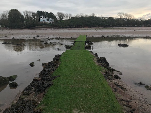
Arrived at Herbrandstone – no go – the tide’s arrived and covered the stepping stones. I’ll have to cross the Sandy Haven Pill (right) further inland at Clay Bridge . The bunkhouse is on the way – so call it a day after 14 miles and finish tomorrow.
Day Three – no buses – so fully self sufficient circular tour to St Ishmael and back before heading home
Whether by design or accident I found myself following well trafficked roads paths or lanes and many motorists treat walkers with indifference. Some parts were downright dangerous for the Coast Path to also be the main road. Other paths were being reconstructed to segregate vehicles and pedestrians. Particularly vulnerable was the alternative route taken by The Wales Coast Path when the tide covered the short cut across the stepping stones.


Sandy Farm where the Wales Coast Path gets confused and entangled with public footpaths. I had to ask for help to find the stepping stones river crossing. Once found I left ZUD nearby while I walked as for as I could and back again. 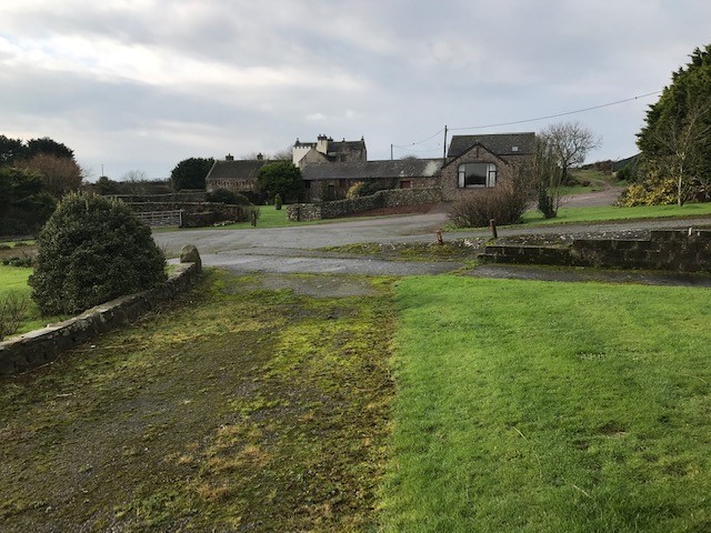
Sandyhaven Pill – the ‘stepping stones’ at last revealed with the outgoing tide. When I approached from the other side yesterday they were hidden beneath the surface and I couldn’t cross. Today, I walked across and linked up . Even though I had just walked all the way round via the next bridging point at Clay Bridge
Soon back on the Coast Path again at Great Castle Head – Great ancient fort site and modernish radar station WWII ?
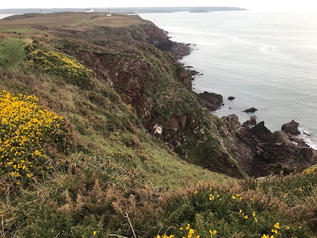
Lindsway Bay – the final beach this trip – now looking for the footpath out of here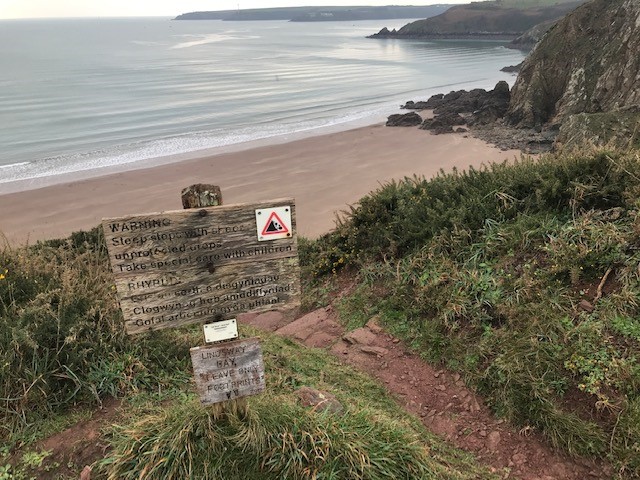
The end of the line this trip, for the Wales Coastal Path before turning inland to St Ishmael on a public footpath. Then a lane lead back to Zud via Skerry Back Cottage making a day tour of twelve mile and 36 miles for the three days


THIS IS THE START LINE NEXT TIME OUT
And now for Home. Which is getting nearer with every walk..
Spare Photo Gallery


