STILLOENGLAND – EPISODE 60 -SKEGNESS TO FOSDYKE – 44 MILES -2339 COMPLETED – 730 TO GO.

This blog , in the form of a letter to our Grandchildren Rosie, Lauren, Stanley, Jake, Rowan and Maisie, is named ” StillOEngland ” and  is the natural successor to 58 Episodes of ” WalkingOEngland” another series of letters, which described  the first two thousand or so, mile  walk around the coastline of England. Adding in Offa’s Dyke Path and Hadrian’s Wall Path   to square the circle, or rather complete the circuit, …..whatever!

It is hoped that “StillOEngland” will have enough capacity to see out the remaining seven hundred odd miles needed to complete the venture

An extra feature , at no extra charge, is the estimate of miles to complete. This figure should be treated cautiously,  and relies on not getting very lost, and a fair bit of guestimation, and a bit of interpretation from Natural England about their version of the coastal route. A plug here for Natural England’s England Coast Path which is on target for 2020 completion. I haven’t been able to totally complete their proposed route, many footpaths are not in place yet, but I religiously keep as near as practically possible to the shoreline, and rely heavily on The various National Trails employing the Acorn icon to adorn their signposts.. When these run out I get in trouble, or when footpaths are diverted but the signage isn’t. This trip identified other reasons for going off piste – frisky ponies and  nesting birds – we’ll come to that later.

More colourful creatures on the map below,  Crimson Worms indentify the extent of my walk, so far, superimposed on Natural England’s Proposed Stretch Map. These can be viewed in greater detail on separate maps for each of the eight regions on Natural England’s website. I’ll make no promises but might try to insert the relevant East Coast Stretch Map in the text, later.

ECP-east-map (norfolk suffolk lincs

-aside- I tried – but keep running into gremlins – the link is the best I can do. The regional maps are very informative. You can compare the status in more detail  of my actually walked route with Natural England’s proposed route. I keep the full set of marked up OS Explorer Maps 1:25 000 Scale for reference, showing where I think I have  been.

Scan_20160608crimson worms

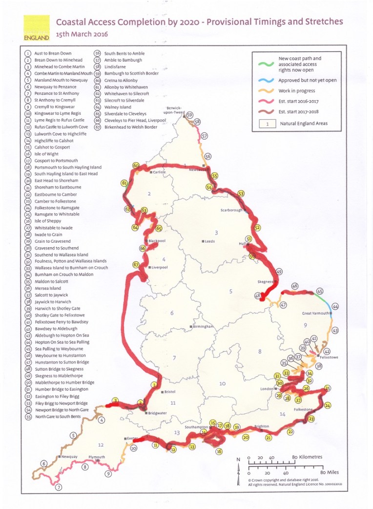
The walk completed so far extends from Combe Martin (3) to Fosdyke (48) and Maldon((34) to Branscombe (10) plus the Isle of Wight (16) and Hunstanton  to Cley next The Sea (46).

Are you sitting comfortably?


Then I’ll begin.


Dear Rosie, Lauren, Stan, Jake, Rowan and Maisie,

All the stuff above is for the benefit of curious adults who want to know what I’m doing when I disappear for several days at a time and return exhausted. I just give them the Magic Word    ” https://still0england.wordpress.com  ” or for previous episodes                      ” https://rdmaccord.wordpress.com “.Even within days of completing a trek, I really cannot remember all that I have walked and the only way is to refer people to these blogs. Even then much of the detail has dissipated.


DSC_0996

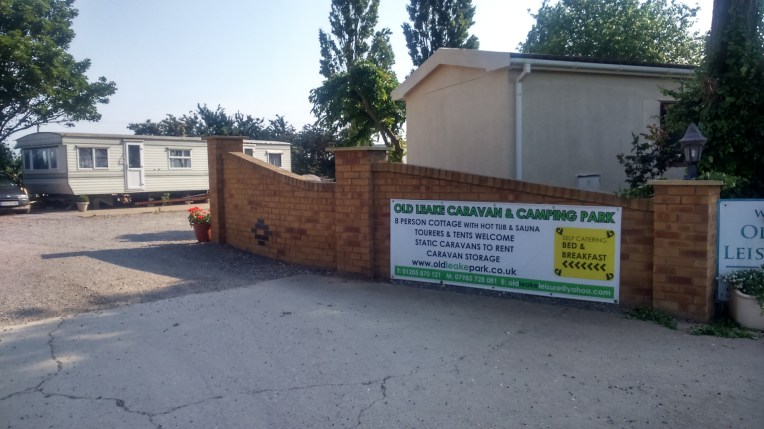
Last week I drove to Lincolnshire and established myself in a small campsite in Old Leake, not far from Boston, on the A52. Old Leake Caravan and Camping Site on Shaw Lane.

The sign on the A52 should really say ‘ Goodbye Skegness’;   the camp site, my home for three days at Old Leake, where the BG number plate was nearly as plentiful as GB;  Number Seven Stagecoach was my alternative to walking the A52;  The A52 was devoid of footpaths and dangerous for walkers, fifty mph was the minimum speed.


Numbers.

Four Crimson Worms

This Episode 60 took place on 5th to 7th June ,2016, Walking Days 169 to 171, staying at Old Leake Leisure Park Camp  Site in Lincolnshire, walking 44 miles  from the previous completion at Skegness to  Fosdyke on the River Welland, via Boston on The Haven

Stagecoach Bus Route No 7  is our favourite, plying for business along the A52, which Nanny and I knew well in our youth , when real Stagecoaches  linked Derby to Nottingham. But out here in the sticks The A52 is a series of country lanes joined together to give the impression of continuity between Stoke and Skegness.

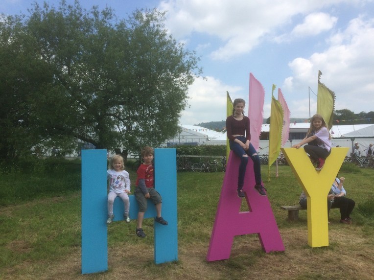
June birthdays;Great Uncle John’s 71st,  Uncle Donald’s 42nd and Rosie’s 12th. And Richard’s, which I’m guessing is somewhat nearer Uncle John’s than Rosie’s?

Explorer Ordnance Survey Maps 249, 261 and 274 were used and found wanting as was my interpretation of their advice.

2295 miles walked to date.

44 miles walked from Skegness to Fosdyke.

Grand Total Miles now completed 2339.  Miles to complete the walk round England  730.

The  first day’s walk started from Skegness Railway Station and I reluctantly struck out on  the A52, trying in vain to get over the Wainfleet Haven or Steeping River to Gibraltar Point; but all the tracks did not provide access or were private and gated, or the bridges down and I was advised to keep away from yet another  designated Miltary Danger Area. I gave up after seven miles,  at Church Lane  and vowed to take a different approach when I resumed walking the next day. I had quickly realised two or three  distinctly  unhelpful features of the landscape; there was no one around and very few buildings, and the fields were generally cauliflowers, peas, potatoes, cabbages and wheat, very big fields and very  repetitive. Easy to get lost!  And no one to advise. If the mind wanders and mine does. So if something was labelled like Coddington’s Yard it got its picture taken for future reference when I was lost.

On the second day, I found a very accommodating business down Church Lane, called Storit, who allowed me to park in their forecourt, while I caught the bus into Boston, that dropped me off near The Stump. I  walked back to Storit, where I’d parked, some 25 miles ,all the time trying to walk the sea bank  wall keeping the Wash out of the low lying fields.  As you can see the vista is quite flat and features for navigating  are hard to find .Although the Stump is visible from anywhere. I walked on top of the earth bank and navigated by counting the Pumphouses which were common but all very similar. When I estimated I was nearing the Danger Zone I cut back inland and eventually found  the A52 and more specifically  the route of Bus number seven.  Which  I JUST  missed . I was walking in the road, as the bus crept up on me; it tootled me for getting in the way; and I reacted with gestures for it to stop; but these were mistaken for reaction to being tootled! I had already done twenty miles that day   It was two hours for the next bus – so I headed  for the car on foot and arrived just ahead of the final bus. I hadn’t intended it, but I’d walked a full 25 miles that day, and it was now dark. Fortunately I remembered where the car and campsite were. Slept well that night. I had now added Boston to the Crimson Worm by completing the Walk from Skeggy. The following pictures  starting at Boston taken every mile or so tell the unfolding tale of the very long journey

Leaving Boston via Custom Quay , looking back along the Haven, past the Parish Church of  St. Guthlac at Fishtoft and into open flat countryside, these fields freshly planted, as far as the eye can see. Any hedges?


At last I think I’ve regained the seashore,  at Freiston Shore, but one peek over the sea bank  and  there’re acres of salt marsh and nothing to reference except an RSPB Nature Reserve.


Very much the same scenery mile after mile, except a herd of cattle, cows and very young calves,  had been keeping pace with me and then turned towards me looking decidedly uncomfortable. They weren’t happy either. Time to head off to safer pastures for me. I had been  a bit up closer and personal, before my retreat; but only stopped for the picture when well out of their range. So my attempt to fully walk the shoreline was thwarted on several counts; it wasn’t really the shoreline except on the map; the Military Danger area was looming ; access was denied and bridges were not safe, and intolerant cows..


I was tired and didn’t want to stop, so only two more shots in the last ten miles , mostly on the A52- not a lot to see here; except the sunset through an irrigation machine  and a still Wainfleet Relief Channel Drain. Back to the car and so to tent.


The next day, still tired from yesterday’s marathon,  I planned a much shorter walk of twelve miles to extend the Crimson Worm even further,  to Fosdyke  on the River Welland, along the seawall, keeping the Wash on my left until I arrived at The Ship for Scampi and Chips and hopefully a bus back to Boston, The following pictures were taken at about mile intervals showing the changing nature of the Wash scenery as I walk away from Boston.


Leaving Boston along The Haven, this time on the West Bank, quite forlorn in places until  the start of the MacMillan Way. Yes, related to the MacMillan Charity, a series of footpaths crossing England . This one ending up in Abbotsbury, some 290 miles away on the other side of the country.

Still snapping every mile or so, the scenery gradually changes from rubbish tip to mass production planting. When level with the tractors I rested and pic-nicked on apples, oranges, salami, cheese and water,  in full view of two more horses ;  all of us  watching the ebbing Haven River from atop the flood bank. It subsequently transpired that ebbing was good for a rest.

I had to push my way past the two horses, it was probably a mistake to get so close. They must have a whiff of the very sweet apples and oranges I was carrying.  I talked them out of raiding my gear, and thought it good to move quickly away.  I was rapidly well clear  and safe .  Or so I thought. Suddenly I was pushed from behind and thought I was being mugged, but on turning round the horses had silently crept up on me and I was being frisked for food. Biting my ruck sack, going in my pockets. They wanted whatever I’d been eating. I talked to them, and photographed them, but they were determined, and one started getting frisky and kicking out. There was nowhere to go , I would never get to the end of the sea wall before them. I moved down the sea wall bank, and so did they. The ebbing tide had revealed the coarse rocks forming rip rap below high tide level.. It was slippery and full of holes but I ventured over it just out of reach of the horses.  I progressed slowly in this way until the horses got bored – they wouldn’t risk stepping on the rocks.

Eventually, first one and then the other disappeared. I RAN FOR THE GATE AT THE END OF THE SEABANK! Sorry Shouting! And then I saw them again, waiting in their paddock. I checked very carefully that they were secure.  I had to pass close by to continue and I’m sure they were laughing. For quite some time after that I kept checking my rear view mirror  , so to speak. Glad tidings of comfort and of joy.

The Witham Mouth is some three miles downstream as The Haven enters the Wash in its lower South West corner. The MacMillan Way continues alongside the Haven on the sea bank, but there’s two miles of Frampton Marsh Nature Reserve, one of the largest areas of saltmarsh in the UK, before reaching  the banks of the River Welland Outfall, which also empties into the Wash. The Norfolk coast is 17 miles away and can be seen on a clear day.


Many birds of prey inhabit these marshes; the rare Motague’s Harrier, Peregrines, Merlin, Short eared Owls, Barn Owls and Hen Harriers. And more rarely Kestrels, Sparrow Hawks, Ospreys and Red Kites.  Pylons are more common and beneath you can just see the top  of the Welland cut.

The end of the line for now, The Ship Inn  at Fosdyke  on the River Welland  and no buses.

The staff suggested  a local taxi firm could take me back to Boston after my scampi and chips and a pint of shandy(medicinal). That warrants a mention in the blog, as does the taxi firm run by Mike and driven by son James, who took me back to the RAV4 which took me back to the campsite at Old Leake.  Go home tomorrow via Baslow, Jake and Maisie., but not before correcting an error in Old  Hunstanton. Refer next blog…..


STILLOENGLAND – EPISODE 59 – BRIDPORT TO BRANSCOMBE – 31 MILES- 2295 MILES COMPLETED – 774 MILES ( or thereabouts ) TO GO


Welcome back to the blog formerly known as WalkingOEngland, now re-christened StillOEngland, recording my exploits walking the coastline of England with added  Hadrian’s Wall Path and Offa’s Dyke Path, which although not coastline, square the circle. If I’m honest, never really understood what that means ,but it feels appropriate, if not impossible, which I s’pose is the point…

…if you study the map by kind permission of Natural England there is a perceptible change from Episode 58, 31 miles in fact. Clue –   it’s on the S W Coast Path Crimson Worm,stretch 10-11.

29 May 2-16 map


Dear Rosie, Lauren, Stanley, Jake, Rowan and Maisie,

I hope you are all enjoying half term -seems it was an intellectual wet one, judging by the pictures of the water fight and the exercising on the Hay Festival Sign.  You were so lucky, and brave, to meet The Gruffalo, I think it was BOJO in Brunette mode.. Book up all six of you for next year. Donald and I are no wiser about Europe despite listening to a volatile panel making up more fairy stories about should we stay or should we go.


IMG_1084

Hay Festival, will never be the same after your visit.


This last thirty one mile walk, took place on the 167th and 168th days of walking, last Saturday and Sunday, 28th and 29th May, 2016. Other numbers that  exercised this Episode were First Buses 9 and 9A, replacing, I thought, Jurassic Coaster Buses X51, X52 and X53. But I could be mistaken, as I was, when I wanted to board one of them and the driver did not share the feeling. The First shall be last. More later!

But sadly Terry Osborne who wanted to come on this particular venture around Lyme Regis had been knobbled by  knee trouble. In retrospect, he couldn’t possibly have attempted any of these steep roller coaster hills and he made the right decision in going for a kneemassage in Budapest instead.


Branscombe Airfield Campsite, friendly , pleasant site on  a very early misty Saturday morning view from the tent, and Sunday morning breaking camp before pulling out. Everything was saturated by condensation. The camp appeared to double as an airstrip and was a  short walk to the South West Coast Path. Next time I’ll fly here


The plan was to join the  S W Coast path heading East towards Lyme Regis, and maybe even Bridport, West Bay, if things went well. The weather was good with a pleasant haze keeping the sun from   overheating me. Shirtsleeves, light trousers, three pairs of socks, walking boots with daysack full of change of clothing,  food, water, milk and wet weather gear. For the curious I also carry, torch, compass, whistle, batteries, re-charger, phone, two white sticks, maps, Elastoplast, sunscreen,  sunhat, gloves, gizmo and guide book. And last, but definitely not least a bogroll.. If you see a tap, fill your bottles; if you see a toilet do the reverse. Without fail.


Daysack food, is any combination of berries, welshcakes, sultanas, muesli bars, dried meat, cheese, pork pies. Apples. It is a large daysack.  I graze every three miles. If I’ve previously bloated myself on Nanny’s cooking prior to leaving home, then I can go several days without what Nanny  would call a proper meal. A proper meal takes too much time, equipment and organisation. If necessary, emergency scampi and chips provide extra sustenance . If available McD’s provide emergency hook up to power supply, wi fi, toilets, coffee , but the downside is the necessity to buy fast food and no spaces in the carpark for a tent pitch.  I’m sure my diet is   frowned upon, but I have given up the beer. Very nearly. Mainly through lack of a sponsor. When I get home, I immediately revert to a Proper Nanny Meal again.


Heading off the lane through Branscombe to the South West Coast Path and the view of Branscombe from the Path. The gently rolling hills are deceptively   well signed until I got lost..Again.

Gentle rolling gives way to abrupt drops overlooking Branscombe mouth.


At Branscombe Mouth, I meant to have a Full English, and at 9ish I  was their first customer, although the Chef couldn’t decide if he was open or not, while he berated the waiting staff. To make it easy, I abandoned full English and instead, I opted for an ice cream and latte . Subsequent customers got their full Englishes, subject to scrutiny of the chef; maybe my face was unbefitting. I departed disgruntled but full of overpriced caffeine and sugar; outside interesting old bangers were gathering, just before the ford. Back on the coastline..


Walking round Beer Head the path is Frightening,  but I took time to send a picture to Terry Osborne, saying  there was no way his knee could have got up here. I gather he sought expert opinion from a Budapest Masseuse that he needs a new knee. This is the most original excuse yet for not joining the walk.

But every silver lining has a black cloud – I managed to miss the proper track but not the caravan park . I walked three sides of a large field  trying to avoid said park, when one would have done.


Welcome to Beer- I don’t mind if I do! A delightful  fishing village that values its allotments over other land use – commendable – and the RNLI Giftshop which is a compulsory stop for me, crewed by Brian and Annette; the seashore serves as boatyard, boathard, fish sales and start point for fishing trips


Greetings from Seaton; the white notice warns of major slips and road closures; the red notice says I really mean it; the diversion is unclear and people ignore the signs but the rockfalls and mudslips are very dangerous. With an outgoing tide I had room  to hop along the beach  from rock to rock, surmising whether it’s better to be on the top or at the bottom when the cliff moves. The reddish brown area viewed from both sides has slumped into the sea. As I passed close by I could see the  very unstable nature of the cliff, and I moved on smartly not wishing to delay by taking close up photos. I was glad to get to the relative shelter of the boat house guarding the entrance to the River Axe.


Crossing the River Axe  and entrance to Axmouth Harbour are two bridges, the new one cunningly disguised as the B3172 modern road, and the other closed to other than pedestrian traffic is the old bridge opened in 1877, the oldest standing concrete bridge in England. The pleasant wheat field with grass track taking me inland away from cliff edges, was the best and safest  way outa here, heading for Lyme Regis.


Axmouth-Lyme Regis Undercliffs  – National Nature Reserve

DSC_0879

This whole stretch of several miles of Undercliff reaching to Lyme Regis is constantly undergoing transformation. Landslips become wilderness, grassland and scrub, then woodland which provide diverse habitats now home to many plants and animals.

Unfortunately Here begins a series of unpleasant occurrences that proved the Undercliff a serendipity free zone. And spooky.

Firstly my gizmo packed up – I rely on this heavily for distances  and pacing myself,- but I carry a re-charger and within twenty minutes gizmo was up and running, but not before it had lost current data. Then my phone and camera followed suit. Re-charge. Should do, but no cable.  Ok don’t panic – send final message to outside world that communication now difficult,  sadly no coverage. No message. And no back up cyber maps.

Preoccupied by this telecommunication failure, I failed to notice as I walked along I was on the wrong track. This became apparent when I popped out of the Undercliff and hit the beach. That should not have happened.

Oh well the tide is going out , there is plenty of room at the cliff base to dodge falling cliffs and my dead reckoning estimates I’m halfway to Lyme Regis. After the next headland  and about another mile, I don’t see Lyme  Regis, but yet  another headland, by which time the gizmo has given up again and the re-charger needs re-charging. Time for a review.

And then I remember, a picture in the RNLI Gift Shop, showing a teenager being plucked off this beach before the tide came in by the Lifeboat. It was their last rescue this month. All systems now down, and probably 13 miles spent was not a good time to be retracing my footsteps. on the unwelcoming Undercliff. I was in retreat mode. And then  I found the S W Coast Path, just 50 yards beyond where I had erringly turned off over a gate which quite clearly warned me not to.

The punishment was probably an extra three miles walked, which meant I got to Lyme  Regis bus stop ten minutes after my bus had departed for Branscombe.

So I started walking back, intending to hitch a ride from these wonderful holiday makers. I must admit up to now, I had viewed all these interlopers as crowding my patch.. go away.. too many people. But now I needed outside help.

At the city limits, I noticed another bus stop with different buses on it, sadly there were no X 51,52 or53’s, but there were 9 and 9A..I didn’t know the time , so I wondered off and found a carpark payment machine which told me, and, miraculously,  a 9A was due in a few minutes, and, even more unbelievably it was going to Branscombe Cross, apparently a mile from my tent.

I spent some time checking the map, and at maximum disruption with wind doing what it does to an unfolding O/S Map – we’ve all done it, or laughed at other people ineptly folding it incorrectly, the 9A was here, asking if I wanted to get on. And I bundled everything on the bus, sticks, rucksack and still wayward map. I questioned the driver closely about going to Branscombe Cross and he wasn’t sure, but another off duty First employee thought it ok. Seated comfortably, I followed the route on the map , its every move for about three quarters of an hour while we visited most towns ,villages, hamlets and isolated outposts, and wondering if I was being taken ever further from my camp.. The two First Bus employees continued their chat about was it or wasn’t it the right place, right up till I recognised my stop.

As I got off,  I noticed a small notice “As from May 4th the x51,52 and 53 will renumbered the 9 and 9A” . But I never worked out why the previous bus stop still said otherwise and that I’d missed the last bus .. It was downhill all the way to the tent, so I practiced the conga, not easy with two sticks and gave up after falling over twice. Overtired?

Slept well that night. Serendipity still exists but not in the Undercliff. Spooky.

I opted and  adopted my preference for camping on this trip, because of the flexibility afforded over hotels and b and b’s; and if necessary the facility for being able to pitch almost anywhere within reach of the coastline. Generally, I pre- book campsites through Pitch-Up, but often vary the booking duration  afterwards, according to weather conditions and the variability of distance walked, prevailing winds and energy shortfall. Most campsites facilities are good, and if you accept the various notices telling you basically don’t do anything; and that campsites are generally only crowded at peak times, and even then if you get going by daybreak you miss the rush. It’s much better, and cheaper, than the regimentation of hotels, hostels, b and b’s , guest houses, camping barns and bunkhouses. I’ve used them all and, even nearly got right to the end of the chain, sleeping rough, on railway stations, trains and buses . But by no means have I got to either extreme of Glamping or the Doss house. Yet!  I fully understand why Nanny is not totally taken with my project, and I probably haven’t necessarily fully explained the less pleasant experiences.  Nanny’s out of range in Auckland right now so I’m safe from being rescued and reorganised for a little while. Shhhh! Don’t tell.

I’ve got an interesting logistical operation coming up- traversing the Wash. It looks  quite remote and devoid of transport, and significantly outside my safe daily  walking range without back up. I’m investigating the possibility of proper hiking and camping, whilst abandoning the car at a central base and striking out from there. Early days. This could only happen in Nanny’s absence. And I’m relying on, nobody actually reading this far into the blog….


Probably a good time to reveal my camping arrangements.  After the great flood, which all but washed away my one man hiking tent, I   replaced it with a two man tent. Needed the extra man to accommodate my bedding arrangements. And someone to talk to? During winter, I insured against waking up frozen to death, by having several layers of duvets and three separate grounsheets and bedroll, and a three seasons sleeping bag. Usually I got too hot. Through Spring and with Summer approaching I am starting to discard layers and my baggage can get lighter – but there’s truth in the saying “ne’er cast a clout till May be out  “. And I always keep spare dry bedding ready in the car, which is completely adaptable to emergency sleeping mode should the weather drive me from the tent.


DSC_0885


The next day Bank Holiday Sunday,  5-30am , I’m  up out, and dismantling the tent , it was hopeless trying to dry out the condensation, with the sun only just peeping over the horizon. So everything in the car, fan on full blast, heading for West Bay, recharging batteries, gizmo, phone/camera, on the coast next to Bridport. Today I would be walking from West Bay to Lyme Regis to join up all the missing links.

Two things  I hadn’t allowed for; the sun melted the mist and most of the day was spent in full sun; and the obtuseness of a First Bus bus driver. My planning was perfect; there’d been no bus stops for two miles ; I knew my particular bus was due; I waited by a layby on a long straight stretch. I hailed him with no question of halfheartedness with both white sticks. As he glided by at regulation 25mph staring through his Ray Charles Raybans I knew he wasn’t going to stop – ever. I had time to even dive in front of him , but that would have been kind of self defeating. He knows , I know. And a First Bus supervisor  now knows. He called him a very  rude word! Just didn’t need his  jobsworth attitude making me walk several extra miles at the end f a long hot day. But the very rude word made me feel much better and the advice to go and get a beer whilst waiting for the catch up bus. IN  defence of bus drivers normally they have been superb, and they know they have something strange on board the moment I fold my map,  untangle my sticks, trip over my rucksack and  hand over my overused bus pass. It’s totally worn. Indignity though, when they lower the platform and then wait for me to get to the old codger’s seat.

In a former life, I was a bus clippie. The worst thing I ever did was give a return ticket to a dog, for which I got a verbal warning. Oh! – yes and another dog incident – but that was my drivers overzealous use of the new fangled concertina doors, allowing the little old lady to get on but shutting the doors on the dog , who was left running alongside the bus still on the lead which said little old lady hadn’t released. It was the first and only time I got to use the emergency bell – three short sharp rings repeated until driver is deafened and stops.Opens doors.Dog hauled aboard, legs slightly shorter and little old lady revived. I think we got away with it.


Those were the days

MAYBE the driver was put off by my cocktail of creams demanded by the management; firstly the one inch layer of sunscreen; then the insect repellent which tastes like mosquitos boiled in paraffin; followed by the Ibuprofen gel (3 x daily) to numb the arthritis and finally the antihistamine when the insect repellent fails. And the beanie  hat, white sticks and black gloves probably give off the wrong image.     I’m after the sympathy vote. Or perhaps someone more sensible wouldn’t be walking round England? (gloves on a hot summer’s day? – one size too small – are very comforting – if your hands hurt). And then there’s the painkillers, blood pressure monitor, defibrillator, spare blood plasma, slings, bandages, manicure set and suicide pills. Only joking.  The gloves ARE the right size, just my hands are swollen. The three pairs of socks repel blisters and the arch supports have cured the pains in the ankles and achilles. Trouble is I now have to buy boots three sizes too big. I’ve mentioned before how important it is to look after your feet and toenails and take time putting boots on.  I now look like Gollum. But I AM enjoying myself. Really

Am so!


West Bay to Lyme Regis – Back to the Coast

Starting on the beach again at West Bay, top left, with the harbour entrance in sight, I was last here exactly one month ago on 29thApril,2016. Top right, looking back into the harbour; middle left, the view down the coast towards Lyme Regis, the white scar on the first hill is the South West Coast Path – I chose to walk along the beach in  bottom picture with Golden Cap the highest point on the southern coast in the distance – spot level 191 metres. Middle right, fishing boats in West Bay Harbour.


The shingle was difficult to walk on, so at the next opportunity, Eype House, I would have stopped for a Latte and swapped to the South West Coast Path aka Monarch’s Way. But the lady in the camp shop said”We don’t do fancy drinks here” and instead served me a tray of filter coffee with cream, milk and biscuits, and a variety of sugars . No argument. Much cheaper than Branscombe. I did then leave the ankle tapping shingle and join the unstable cliff top route via The National Trust Property at Down House Farm.


DSC_0900

No aplogies – how could I reduce this view – still not quite full size – looking back over a mile to West Bay


DSC_0899

The same but getting a bit on edge


DSC_0901

And looking  towards Lyme Regis at Thorncombe Beacon


DSC_0904

Getting a bit crowded approaching Seatown


On Golden Cap, spot level 191 metres. The Monument from the National Trust to an earlier leader, The Earl Of Antrim; looking East to East Ebb; and looking West to Lyme Bay


DSC_0917

Spanish guests. Thadius and Marie, not her proper name, my English tongue apparently, would never be capable of pronouncing it correctly. They wanted to know all about my walk, and the blog. They wanted to know where my next walk was. They talked of walking in Spain and how I should come over in the Winter; how all the villages would know I was coming and they’d be helpful and cheer me on. Lodging , food and drink would be no problem.  Just like Laurie Lee and how he walked out one midsummer morning leaving the Cotswolds to walk to London , but ended up walking  across Spain, and got involved in the outbreak of their Civil War.  He chose Spain because he knew the Spanish for “Will you please give a drink of water?”

He took his violin and could busk his way around; I can’t even dance the conga without falling over.  Enjoy the blog Marie and Thadius. See you in Spain. But not till I’ve finished England and then Wales. But not Scotland. Maybe John O’Groats to Lands End.

DSC_0918

And so I got lost – all the ingredients – a long and interesting chat – a poorly signposted and long and uninteresting  diversion  – loss of concentration – and a blind bus. All this and it was very hot.

DSC_0921

About to cross The River Char at Charmouth by the footbridge. The bay cliffs beyond Charmouth are very unstable so the diverted path makes you turn right , north, and skirt the higher ground , 177metres, a mile or so inland.  You enter Lyme Regis alongside the A3052. But no signs and the  desire for a bus meant I followed the main road all the way into  Lyme.

DSC_0922

Even traffic signs were difficult to read on the main road, this was supposed to tell me to turn left to Lyme. This is a mile or so from  approaching the point where I unsuccessfully hailed a bus.


The cliffs are very unstable between Charmouth and Lyme Regis and the diversion takes you well away from the coastline following the bus route for the most part.  They do not believe in bus stops, not one was seen on the side I was walking after Charmouth. The tradition is that you can usually hail a bus from anywhere reasonable and it will stop somewhere safe. I had now given up on  the walk to Lyme Bay and was now ready to get back to the car and finish off next visit.  I worked out the pattern of buses heading from  Lyme Bay to Bridport and with the timetable estimated that one should come along  just before 3pm. I arranged to be in a safe layby, traffic could overtake and I was quite pleased that I could see the bus from a long way off. It trundled along and carried on past despite my signals and protestations. The next bus was two hours.  So I resumed walking Lyme Bay and waited for it there.

Once back in Bridport and following a chat with the bus supervisor, and his superb advice to go and get a beer while the connecting bus arrives, and his assessment of his bus driver, I felt much better. But very tired. I had walked three hours longer than intended and still had a long drive home.

DSC_0923

The very welcome pub alongside the bus station and  the River Brit, with excellent live band. And twenty minutes before my connection.


Otherwise an excellent weekend’s walking 31 miles and the next starting point on the South West Coast Path, will be a return to the campsite in Branscombe Airstrip.


But I will probably return to The Wash, it’ll be cooler and flatter, and no buses.


“WALKINGOENGLAND” BECOMES “STILLOENGLAND” – Episode 58 – 2264 miles done / 805 miles to go .

This blog records my journey round the coastline of England in the form of a letter to our six Grandchildren, in order of appearance; Rosie; Lauren; Stan; Jake; Rowan; and Maisie.  It began life entitled “Walking OEngland”  but has now been re-named  “StillOEngland” simply because I ran out of space.


DSC_0769

Dear Rosie, Lauren, Stan, Jake, Rowan and Maisie,

The walk round England proceeds apace; regular features include sea, sand , footprints and challenging weather, as in the picture above.

Unfortunately the old blog, OEngland, couldn’t cope and I’ve reinvented things and will carry on the challenge to completely circumnavigate England on foot by my seventieth birthday in November 2017, and record it on StillOEngland

A previous feature of OEngland -The Numbers – has been distilled to the lowest common denominator, being distance covered and estimated distance left to travel. The former is 2264 miles;   the latter is estimated to be  805 miles left to walk. A grand total of about 3070 miles. { I still have ninety per cent of The S W Coast Path to complete, much of  Norfolk , Suffolk and North Essex,  And Newcastle to Berwick on Tweed.  }

I was advised that the English coastline was about 2800 miles..

Deduct about 250 miles from my  estimate ( I’ve included Offa’s Dyke and Hadrian’s Wall  – they didn’t)  gives 2820 miles -near enough! When you consider how many times I get lost, the comparison is quite surprising!  Let’s hope my estimate to finish is realistic. In terms of how many days walking , I guestimate about 70; I’ve already walked on 166 separate days. Just to complicate things That includes Hadrian’s Wall but not Offa’s Dyke


Let’s reacquaint ourselves with the The Crimson Worms wriggling their way round the coast. One has swallowed its own tale on the Isle of Wight and the other three will absorb each other as the walk nears completion.

Progress to 16 May 2016

Four crimson worms exist;  the longest from  3 Coombe Martin to Skegness, Gibraltar Point 49; and the next from Bridport  22, to Maldon, 34; COMPLETED 16, Isle of Wight; and 46, Hunstanton to Cley next the Sea, a bit of an aberration when Andy, Caroline, Jake and Maisie went on holiday.