
My present final position is Clacton-on-Sea heading for the Suffolk Border. I have completed my version of The Essex Coast Path from London via Tilbury, Canvey Island, Southend -on-Sea, Shoeburyness, Foulness Broomway, Burnham, Bradwell, Northey Island, Maldon, Salcott cum Varley, Mersea Island, Clear Point, Jaywick and Clacton Pier.
All the Islands are proving problematic.
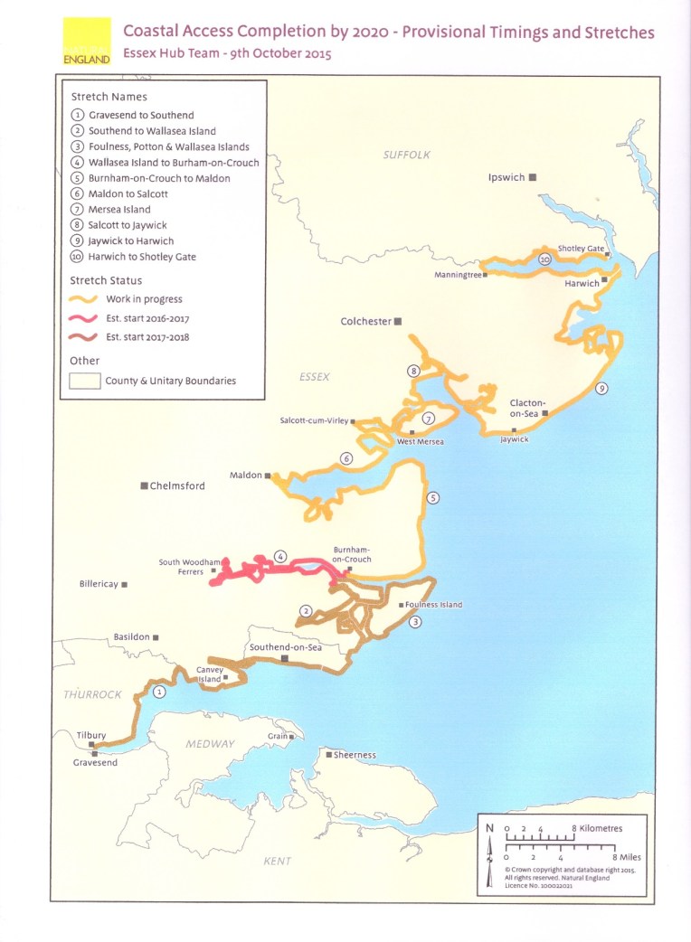
The Proposed England Coast Path in Essex courtesy of Natural England.
For my project, Walking Round England I think the proposed path circumnavigating each individual Island in Essex is excessive. Some are unapproachable or forbidden eg Foulness; some are private, and unwilling to accept visitors eg Osea; others are protected but accept visitors by invitation eg Northey. Other Islands are almost inland, eg Potton and Wallasea and some are connected by causeways eg Mersea Island and Canvey Island is below Sea level. So the strategy is to complete the Mainland Coast Path wherever it is defined and then join each island by the most direct route and leave by the most direct exit which in some cases might be by ferry. I would be surprised if the final Coast Path does include all the options above – I cannot , for instance see that the Authorities are going to persuade Foulness Island to be accessible.
. My completed version will represent the coast path on the seaward side of each island – if permitted. I will revise the map accordingly for the next episode. The Definitive England Coast Path will not necessarily be finalised until 2020.
Wednesday, November 9th 2016
Dear Rosie, Lauren, Stan, Jake, Rowan and Maisie,
Nanny and Bob! returned to their roots in Essex for four days last week to continue walking the English coastline. We even managed to attract two Essex ladies to join in minus white stilettos and handbags; Elizabeth for a huge 12 miles on Saturday and Marilyn(II) for several unspecified but respectable miles on Monday. My gps gizmo is playing up, so I’m lost without it…. It’s interesting to see my batteries last longer than the cyber aids I carry with me.
Meteorologically speaking, in summery, the weather was wintery, and we avoided the rain, but for a brief forecasted personal lone drenching on Sunday. I managed to keep my guest walkers on the straight and narrow salt marsh paths and only got lost again when on my own, with added mud, because I thought I saw a short cut through the marshes. I didn’t. It wasn’t. But I still keep the wasted miles for my overall tally. I’m at pains to report that the 2725 mile Grand Total represents nothing other than my continuous joined up journey round England’s coast. An accurate measurement of England’s perimeter it ain’t. To two decimal places , as well.
I started on O/S Map 176 near Heybridge Basin near Maldon with Elizabeth walking and Marilyn (I) in the RAV4 Back Up programmed to intercept at regular intervals in case of emergencies. We kept obediently to the seawall past Goldhanger and made it comfortably? – sometimes uncomfortably due to lack of convenience – to Tollesbury Marina and the very convenient Yacht Club Coffee Shop before the shortened daylight closed in on us. Yet again I have to concede an accommodation upgrade totally out of my usual camping standards courtesy of Elizabeth, who having been driven to the limits of her endurance had the very good grace to invite us home. Although you may never know how difficult it is for me to forsake the luxuries and return to relative camping squalor. And the habit catches on to the back up crew, subsequently demanding equivalent hotel status after the Elizabeth hospitality was complete. Thank you Elizabeth and your guest walk of twelve miles was impressive. I hope you recover!
The second day saw me onto O/S Map 184 with a target of getting onto Mersea Island. I achieved this via country lanes dodging white van man and Essex Boy Racers. The two Marilyns found me fetched up in a layby approaching West Mersea at twilight and I was fed, watered and returned to the hotel.
I started day three back on Mersea Island to pursue the coast path to reach the ferry for Brightlingsea and Point Clear. If it had been operating. Only a summer service. So more work needed here to avoid leaving a hole in my itinerary. After a rendezvous with the Marilyns at the friendly Seaview Café, Marilyn II joined me for the second half along the foreshore, and we kept up quite a pace to the next rendezvous with Marilyn I. By the ferry car park – if it were running.More food liquid and home comforts. Thank you also , Marilyn II, for the further hospitality and civilised home comforts afforded to us. The alternative of changing out of damp dirty clothes into damp clean clothes in a sodden pup tent isn’t inspiring as winter approaches.
Day four began at the ferry discharge point at Point Clear on the opposite bank of the River Colne – if it had been running -. Target one was to extricate myself from a vast decaying caravan park , through ditto Jaywick to Clacton and finish at the Pier. Target achieved by Midday at Clacton RNLI, and then Clacton Pier, after paying homage at the site of Butlins Holiday Camp, now housing. Forty two miles to add to the total this trip.
And so back home to Shropshire – you can follow the walking journey below – in pictures
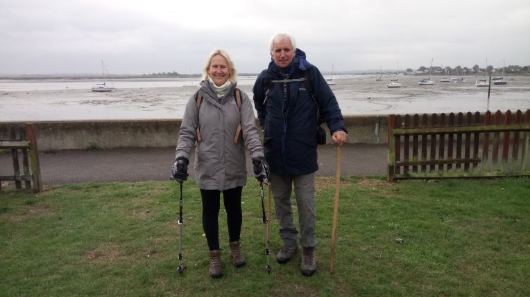
Something missing? – snow? Bobl and guest Elizabeth starting out at Heybridge Basin.


Distinctive Essex marshes;Essex Girl;Essex Boy; Essex dog walkers; and Angel of the East. In Essex?


Various views of the River Blackwater, marshes, seawall and Bradwell Power Station on the other bank – soon? to be built by the Chinese, much to the consternation of the locals.
Elizabeth minus sticks – we ditched them early doors – no snow…..


The marshes gave way to Tollesbury Marina – end of day one


Day Two started at Tollesbury Marina again, with a variety of accommodation, whilst the coast path now heads inland. Flooding is always an option.


The route to Mersea Island via Salcott cum Virley,Great and Little Wigborough, Peldon and Mersea Island Causeway, The Strood, and finally back at the waterside where I finished the second day.
On the third day I returned to Mersea Island and found West Mersea Marina.


The Marina and RNLI Station looking towards the Salcott and Strood Channels.
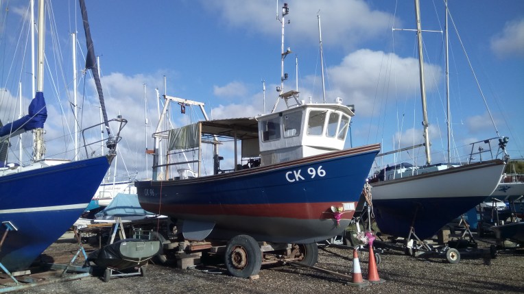


Fiddlers’ Green -One sailor’s last voyage, fetched up on the hard at West Mersea Marina.


Maybe Lady Grace is the answer to my ferry problems – next time out I’ll take its advertised boat trip to Point Clear – or not?
The RNLI Station was closed and my short cuts from hard to pontoons always involve sticky mud


The shoreline from West Mersea approaching Mersea Flats, generally level but anything higher has some erosion problems.
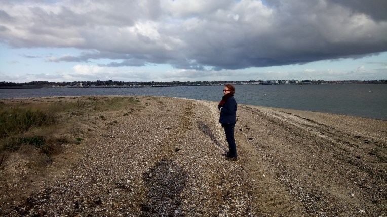
Marilyn II, pondering the lack of ferry from East Mersea to Point Clear opposite. Arriving in Summer would have helped, but we had the bale out option of Marilyn I tracking us by car – which in view of that cloud, was evidently imminently necessary. We had alternative views of Marilyn II but captured on video rather than still photo. Sadly this blog does not support movies – I won’t pay the premium – so we stay put and remain static…..


We rendezvous with Marilyn I at the National Nature Reserve Car Park, after disturbing the locals


Day four begins with Ferry Boat Inn, Point Clear and its eclectic buildings, but no ferry.


A few miles apart, compare and contrast the Abbey at St Osyth and worn out housing in Jaywick – the graffiti appeared to be against new flats….. caught in the middle was the promenade at Seawick.
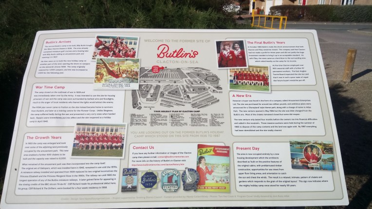 This is the plaque commemorating the demise of Butlin’s Holiday Camp at Clacton-on-Sea. The Camp was opened in 1938 only to be taken over by the Army for the War years and reopened in 1946 after hostilities ceased. Very popular for over thirty years, following three years of losses the camp closed in 1983 only to reopen and fold again in 1984; by 1987 everything had been dismantled, demolished or disposed of. It is now a housing site…. Bye Dee Bye….
There was no indication of a week’s visit in the early sixties by Bob!, Dave and Pip. My main recollection was endless playing of the Kinks Sunny Afternoon…. I think.


Welcome to Clacton! The RNLI Staion on the Clacton Promenade; and inside the RNLI Shop with Tony and Pam dispensing souvenirs; and then the Pier hoves into view.


Clacton on Sea Pier, final venue for this trip
