Above; The end of the line for The Northumberland Coast Path, which I had religiously but unsuccessfully tried to follow all the way from North Shields, Newcastle. Part of my penance for straying from the pilgrims’ route was having to walk alongside the extremely busy A1 for several miles. There are quite a few heathen drivers out there, wishing you’d pass by on the other side.
The Bridges of Berwick upon Tweed taken from the bus route outa there; I only had 17 minutes to explore and make sure I caught the Sunday service X18 back to Vera abandoned near the A1 in Fenwick, pronounced Fennnick.
Haste ye back to Bonnie Scotland. I think I might just do that…..but Wales is next!
Below; The Crimson worm represents my progress around England’s coastline, and includes Hadrian’s Wall plus Offa’s Dyke…..

The end of the crimson line on the Scottish Border, at Berwick upon Tweed.
Only the S W Coast Path left to complete around Land’s End.
Map courtesy of Ordnance Survey with my Crimson overlay depicting my route around England’s coastline, plus Hadrian’s Wall and Offa’s Dyke National Trails.
Dear Rosie, Lauren, Stan, Jake, Rowan and Maisie,
Well. Well. Well! I did IT . I got to Scotland. Just by putting one foot in front of the other. Nothing special. But I do feel a tiny bit proud. Whatever you lot do – you don’t have to do it all at once – just put one foot in front of the other – keep going – and you’ll get there.
Rosie! Your winning the hundred metres was putting one foot in front of the other rather faster than I did and you have such a lovely action; Lauren, taking up the tennis racquet in response to Wimbledon, you are going to be good – keep practicing, small steps at first; Stan, the man with a plan, already three Welsh Peak climbs under his belt and your football control is very good for your age – use both feet ; Jake, tennis, cricket and football, Andy Murray, Jo Root and Harry Kane should be worried – you remind me of – er well – er , – me, but use the left foot more; Rowan , I’ve seen your Ballet clip, such grace – and attitude…practice those steps; and fearless Maisie perhaps smaller steps and less danger.
But The Walk goes on. Next is the final visit to the S W Coast Path on Thursday to complete everything at Land’s End. We still don’t know whether the Northern or the Southern Crimson Worm will get there first, but Major Andy, Captain Donald, Sgt Andy and Sapper Stan will all be there to witness it. We’re staying at Mousehole AFC Campsite for any late arrivals.
NUMBERS
I walked 109 miles in seven days, alone this time, on the pilgrims way along the Northumberland Coast Path, bringing the total to 3339 miles on 263 separate Walking Days.
Rav4 Vera has clocked over 150,000 miles, not all down to The Walk, but certainly, I couldn’t do it without her. Likewise the back up driver albeit 12,000 miles away with Omi, in Shaky New Zealand, where recently the ORBLAX amazingly didn’t beat the Lions. I find this incredible, since so many Kiwis were telling me until quite recently how poor the Lions were….. it is quite normal for New Zealand to go into collective depression when they realise the Orblax are only human. Just get in touch when you’re ready….
Walking alone, gave time for reflecting on the previous well over three thousand miles I’d walked around England’s Coast and all I can write is that my thoughts are completely scrambled. All those worthy comments, pithy sayings and clever conversations made up along the way for outpouring into the blog have deserted me. I’m very weary, but not in a bad way . The sort of weariness that leads to a deep and long night’s sleep. Very satisfying. It’s a sort of Euphoric malaise – is that possible? Or smug, as Henri would have it ( I make no apologies that only a very few will appreciate that).

When I get to Land’s End I think I will be very proud of myself. I might even be tired and emotional, with the aid of a bottle or two of NZ bubbly. I don’t drink much – so it won’t take a lot of bubbles.
Excuse me a minute , the screen’s gone all blurry.. Wherever you are, on Sunday and Monday at Land’s End, I’ll drink a toast to you all. If you’re wondering why twice – well there’s a Northern Crimson Worm and a Southern Crimson Worm and they both have to pass the finish line. Major Big Andy is in command of navigation, tactics, strategy and logic, with a brief to get me there. I deliberately haven’t read any orders, so I can’t tell you who will win. We just put one foot in front of the other – and we get there…..
Enough of this blubbing – get on with the pictures, remember I was alone; I couldn’t even stick to the Holy Trail, I may have strayed off the straight and narrow coast path, so don’t blame me if some of the pictures aren’t what I thought they were!
And finally congratulations to Terry, who this week climbed 3260 metres up the Matterhorn as the lone male in a party of five – that’s some baggage handling El Tel. Well done! It was the practice you put in on the S W Coast Path what dunnit.
This day began from Baslow and headed North West to Manchester Airport when Marilyn was departing for Auckland and Omi. Leaving the airport, I sorted out the maze of the M60 and M62, heading for Leeds and eventually Widdrington, North of Newcastle, my base for several days, while I walked the Northumberland Coast Path to Berwick.
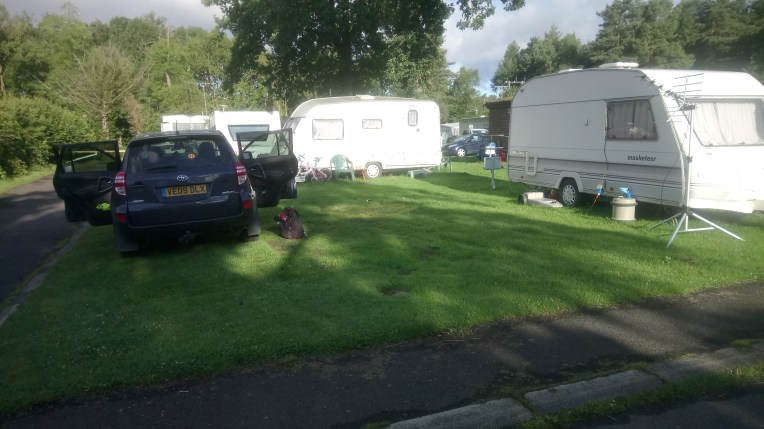
Near Widdrington but where’s the tent? I forgot to take my Campsite location picture until I was leaving. I originally booked three nights, but added two more nights because I was no where near Berwick. I stayed a sixth night, because the circuitous route added miles to the walk. Thank you Seddons Camp Site for being so accommodating, and good luck with the red squirrels.


My car location pictures at Whitley Bay! Eccentric? What’s more eccentric? Imagine going into a Police Station asking for help finding the car? It has been known!


As with so much of the East Coast, Whitley Bay is not immune from erosion problems as witnessed by the ongoing reconstruction of the promenade heading back towards North Pier of the Tynemouth Harbour passing the closed Life Boat House on the way. I was barred from the North Pier by an unwelcome notice saying open from 7am to 8pm. but It was firmly locked at 4pm. Inside the harbour it was as calm as a millpond .


Not very busy harbourside heading for the North Shields Metro Station. The Registered port for the dark blue and white boat was Kirkcudbright, whose name will evoke from Susan, John and Janet various amused memories of unnecessarily long name boards of our youthful homes. I talked to the crew, hoping to get in touch with my roots, only to find that what I first took as a broad Scottish accent talking Gaelic, was the other local dialect called Polish.
I eventually found the metro and tried to pay for a ticket back to Whitley Bay and was informed no one pays after six o’ clock; apparently a local custom built up on fortuitously inoperative ticket machines and knowledge that there are no inspectors after that hour. I shared the profits with a local sweet shop. Reward for six miles that day. Not a bad start.


Religiously sticking to the promenade out of Whitley Bay, where I had some previous, on to St Mary’s Island and lighthouse approached only by causeway – not at high tide!


Moving out of Whitely Bay Heading for delicately named Seaton Sluice and into sand dune territory – not the landscape I’d anticipated- heading for Hartley Links


Arriving at Blythe on an informal footpath – I’m free to choose my own route – which isn’t obvious. Following the south bank of the River Blythe after visiting the fishermen on the west pier, I’m corralled inland. There is no way over to the East Pier and he fishermen say it is dangerous anyway.


Blythe south harbour and lifeboat station
I head for the A189 along the River Blythe, to the nearest bridging point. But soon I am forced further inland to the A1147 to Stakeford and the B1334 to North Seaton.


.The inland route was uninspiring until I reached Newbiggin Bay, but the Bates Mine water treatment process to cleanse rising polluted minewater was interesting and indicative of the mess previous industry has left behind.
The coast at Newbiggin Point….


………Newbiggin by the Sea,- St Barts Church where ex Army Surveyor Chris was perfecting his drone Survey of the Church . It’s a far cry from the Theodolite and level surveys I trained with in 1966….. and subsequently worked with as a Site Engineer round the world. I still have a dumpy level and I’m not afraid to use it.


I just thought a plumber repairing a water pipe beneath 11,000 volt lines was shocking, as were the two sulkies happily amusing, following the coast road. Gettit?


The Power Station occupied the foreshore and forced me inland but back on the beach again by Lynmouth and Druridge Bay. I found a very popular home made ice cream shop at Cresswell – I know – my paunch. And the RNLI station told of many brave rescues, in particular dragging the boats several miles through the lanes because the seas prevented launching from the harbour.


Wild Life Photographers near Widdrington, had spotted a nest of White Barn owls and staked out these cottages. Chris with his tripod was not ashamed to be blogged but the others I respected their wish not to be photographed. Get in touch if you do read this and give me more accurate copy!


Playing in the sand at Druridge Bay – and a fishing boat comes very close to the beach dragging his nets in. They are my foot prints! But look at the direction of travel? How DID I do that?


Coquet Island – a Benedictine monastic cell and medieval tower appear about a mile offshore – zoom in and read the notice!


The South Jetty and North Pier of Warkworth Harbour at Amble with brightly painted boats and a new Amble lifeboat station. More souvenirs – the shop was open and they opened up more, for me to see the life boats.


The Elizabeth and Leonard moored in the harbour with the Rib under cover, but ready for action.
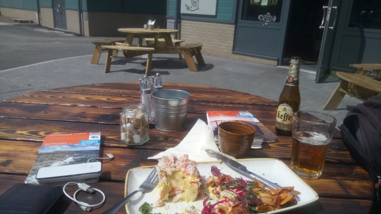
Lunch today is crab and crayfish salad with a beer at The Fat Mermaid, part of a modern harbour development at Amble on the River Coquet next to Warkworth Harbour. Delicious! If I’m careful, I can now eat seafood – as opposed to fish – which I ‘ve tried very hard with, but still can’t digest – even more so if the thing is still looking at me….


Following the River Coquet upstream to Warkworth and its Castle, we are now well into the Northumberland Coast Path heading for Berwick upon Tweed.


Leaving Warkworth via the bridges over the River Coquet, heading for Birling Links , the seashore and St Oswald’s way.


Approaching Alnmouth the circuitous way. A shorter route aong the seashore and fording the River Aln was denied me because the tide was too high.


The Alnmouth Golf Course shares the coast path until the seashore takes over. Spot the ducklings being taught how to surf…..


Boulmer Life boat house. The path has become very formal and well maintained.


World famous Craster kippers being smoked and the Jolly Fisherman where I had another crab lunch. At first I thought the building was on fire!


Craster Harbour and the IRB Station.
Dunstanburgh Castle appears ahead – the journey is gentle and rolling, the last of the Rolling English Road


For the most part so far, the weather has been kind; the odd wind in my face; not too hot; and the occasional drop of rain. The terrain is undulating and easy to walk as I pass NT’s Newton Point on my way to Beadnall Bay and Beadnall


Starting to move more swiftly along with the help of the coast path, road , footpath beach and dunes all being like minded, heading together in the general direction of my overall objective – Berwick upon Tweed. I’m making good progress……

Walking along Annstead Links, Seahouses Harbour appears in the early evening. I like the look of that breakwater jetty in the middle distance.
So much so that I sidestepped the gate and got very good views from the pierhead and extra specially rewarded with the 17-57pm fishing boat returning to harbour, with what looks like a huge catch of tourists!


Strolling round the harbour shops – all now closed, I spotted a print that I’m sure I might otherwise have purchased.
Starting again next morning – Saturday – returning to Seahouses – parking Vera in an all day carpark, I wandered around the Coastguard HQ, the Lifeboat Station and a monument – THE RESCUE – to seafarers guardians.
Now aware that my time was running out. Today was my last full day of walking and I had 32 miles left to complete. Tomorrow was Sunday and half a day’s walking’ and all that uncertainty of Sunday bus schedules. I checked that the best bus out of Berwick tomorrow left the Bridge -( which Bridge, there are three?) – at 14-17pm. There was another four hours later, which would mean I’d probably fall asleep driving home.
I still had to break camp at Widdrington as well – better get a shift in.


and returning to the pilgrims trail at St Aidan’s Dunes. Heading for Holy Island.
Now we come to the bit where it all falls apart. For no good reason ST Oswald took his way AND the Northumberland Coast Path inland leaving Seahouses. I have no higher authority to consult or disobey – Nanny’s in Auckland – not Bishop’s – its namesake – 12,000 miles downunder. So the beach route it is then. Oh Wicked! Next stop Bamburgh Castle

And that’s when it started raining. I headed for the castle, but it was guarded by shifting sand dunes behind that innocuous grassy mound lie many and varied tracks and trails through the overgrowth. The rain in itself wasn’t soaking. It was the accumulation of moisture on the vegetation at body height, that obligingly tipped itself on to me as I shoved my way anywhere. I was drenched.


I spied an unusual gathering of people in costume – they weren’t wet – they obviously knew the route through the sand dune maze and were aware of the soaking guardian, qualities of the ferns, reeds, gorse, brambles and heavy bladed sharp grass. I’m not moaning , but they were very inhospitable and wouldn’t let me pass. Photographed one footman putting his foot on – his colleague wasn’t too gracious – saying the ambience wasn’t right – I just found that a medieval character getting dressed in the back of a modern car to re – enact some worthy skirmish hundreds of years hence, was – er -interesting…. even though I was drowning inside.
Nothing would get me inside the locked gates to shelter and change into dry clothing, so I watched the battle. They weren’t holding back, and I think it was real blood. Better humour these guys; in so doing I turned tail and retraced my steps back through the soaking dunes, they reinvigorated and replenished with a fresh drop of rain.
When you’re really, really wet – you’d think another soaking is water off a duck’s back. Well! It is and it isn’t. I kept up a good pace to fend of any chill and didn’t stop till I got to Budle Bay and found a friendly, unoccupied WWII Pill Box .
Midday .
Lunch.
Very wet lunch. I now know why I carry a complete change of clothes in plastic bags in my rucksack. More than one family group of hikers visibly veered off course as I dried out and changed. I’d always assumed the worst any time I came across odd male – always male – behaviour in derelict structures; now I realise there might be quite plausible explanations.
There’s a bit of coast in the first picture below, but the rest is coastless terminating at the A1 with traffic thundering by and no footpath. Time to head off to Holy Island


WELL -I don’t know who set the course for the various trails from now on, but they should really go and get their theodolites sharpened. St Oswald and his advisers must have been at the mead and were taking the Rolling English road with them. Even though my map was a soggy mess, I could see a faster route to Holy Island. Unfortunately it required two miles alongside a very fast A1 clearway. I held out till I got to Fenwick, where the A1 intercepted St Oswald’s Way and the Northumberland Coast Path. Trades descriptions should be informed -there’s nil coastal to see here.
After crossing the main east coast railway line very quickly, I also very quickly came across the road to Holy Island. The tide’s in and the causeway clearly closed. , unable to part the seas, I left St Oswald to his way and carried on northwards along the Northumberland Coast Path, now firmly reinstated on the coast line.

That’s Holy Island over there! Retreat to the tent and hope for better tomorrow.
Upon returning very early Sunday after breaking camp and leaving Widdrington the tide had gone out but then came back in as it has done forever. It certainly wasn’t hanging around waiting for me. Maybe next time?
Now for a straightforward fast walk to the bus on Berwick Bridge; I followed the coast path all the way to the X18 Bus Stop. Here is the final half day in Pictures .
AVE ATQUE VALE BERWICKIUS!


Coffee at Goswick Golf Club – Walkers welcome! Alongside Lindisfarne National Nature Reserve


The coast path does exactly that – keeps alongside the coast unlike earlier. Eventually catch sight of the Pier marking where the Tweed enters the North Sea.
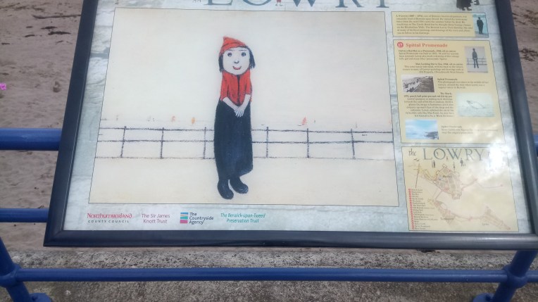
Lowry spent regular Summer holidays here and there are many such displays of his particular talent exhibited in Berwick, often exactly where he’d set up his easel.
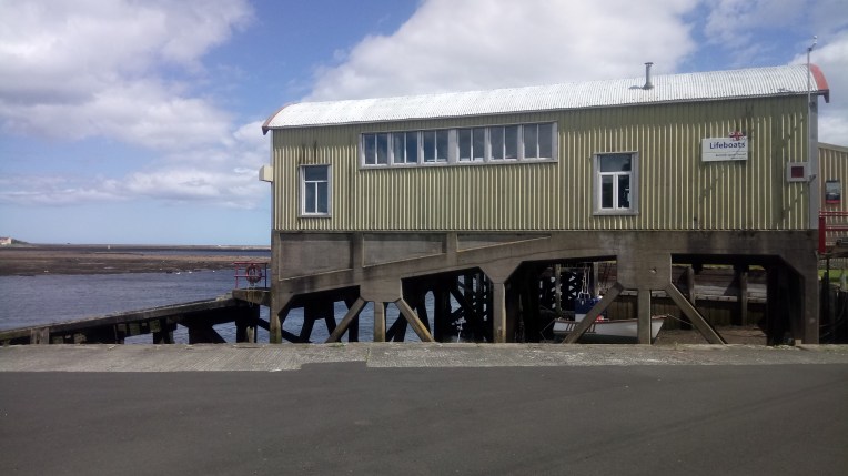
And the last word goes to Berwick Life Boat Station