STILL0ENGLAND/87 – 249 Days walking 3,155 miles around the perimeter of England. This trip, I walked seventy miles in Cornwall over six days from Harlyn Beach to St Ives, of which Stan did 13 miles in one day.


DSC_1613

I’ve walked all that………and experienced the blues.


Dear Rosie, Lauren, Stan, Jake, Rowan and Maisie,

I clearly remember fantastic Brisbane blue as one deep solid blue colour, maybe two , as the sky and the sea were obviously not the same; but I  never realised how many different colours blue there  were, until I visited Cornwall. And how clear and bright the light was.  It reflects from the sea and sand.  I covered up and used sunscreen, with my battered Brisbane sunhat, but still came away several shades darker.  You must go one summer and experience it for yourselves. There are still a few more trips left for me  to complete on the Cornish Peninsular, so pester your parents, more than usual and come along. When the sun is shining.  All budding artists must make it compulsory, Lauren! We can take you on the next trip. Hotels! Not camping.  Nanny is going, too.


NUMBERS.

Here’s some Arithmetic and Geography homework,for Halfterm .


As I was going to St Ives,

I met a man with seven wives,

Each wife had seven sacks,

Each sack had seven cats,

Each cat had seven kits.

Kits, cats,, sacks and wives,

How many were there going to St Ives?


Answers on a postcard please to

Mr Macavity, Cats Migration League, Feline Lane,  Padstow, Mewlyn

St Austel, St Just, St Agnes,  St Erth  or  anywhere but St Ives.     Clue……,


PROGRESS – Map courtesy of  Natural England, with my completed route overlaid in CrimsonScan_20170526.jpg

The Northern Crimson Worm has slithered to St Ives, within 24 miles of  Land’s End, whilst its Southern counterpart is still run aground around Charlestown and 111 miles adrift but well into Cornwall. If I  add in Berwick to Wallsend then the total left to complete the circumnavigation of England is probably 200 miles, with no getting lost.

DSC_1625

Slightly indistinct on the Cornish Peninsular, but at least the midlands blizzard has dissipated.


Six days walking on the South West Coast Path in Cornwall from  Harlyn near Padstow to St Ives has worn me out, just in time for half term holidays.  I covered 70 miles and the weather, which started very misty – almost rain – became warmer and eventually found me shedding my boots, trousers rolled up, walking in the surf to keep cool. I got a bit lost in my thoughts and the recollections come through intermittently which is reflected in my ramblings.  There’s too much going on in six days and seventy miles for it all to be recorded accurately. With that in mind read on….

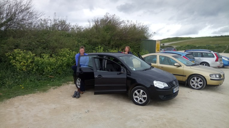
The first two nights, we stayed at Old McDonald’s Farm near Porthcothan, which had a full range of animal and wheeled attractions,and clock golf, which Stan had all to himself. The rest of the time I spent at Trevella Campsite, again very quiet as it was out of season. I can imagine both sites heaving now that we approach half term holidays.  DSC_1412DSC_1482

Throughout this trip and all around Cornwall the buses and drivers have been superb. I used 47, 56, 87 and T1 Routes and referred constantly to the excellent Kernow Local Bus Guide.


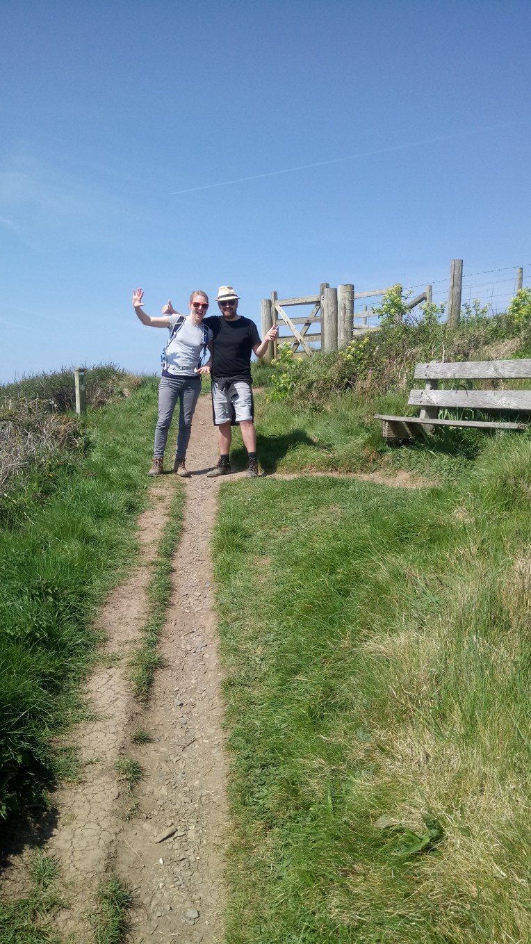
The first day walking out on my own, starting from Harlyn Beach, I rounded Trevose Head and I reached Porthcothan Beach.


On day two, Donald and Stan had arrived and  kept me company for the stretch between Porthcothan and Newquay, walking thirteen miles in a day. Stan was rewarded with a hilarious double decker return  bus drive through the narrowest of Cornish lanes, with unlopped trees  crashing on the roof and sides, whilst unnerved motorists twisted, turned and reversed (a lost art) to keep out of the bus’s  way. One householder was too busy felling his own trees to notice the bus was delayed by his wheelbarrow and branches blocking the lane. Stan’s verdict; very brilliant bus journey; better than Alton Towers.DSC_1445.JPG

Stan driving to our tented home, from the top deck front seat.


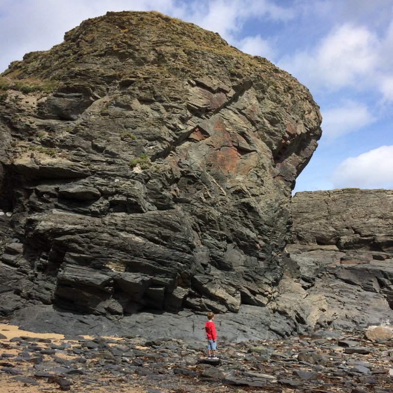
Sunday was a day of walking rest, nearly. We visited Porthcothan Beach, and were fascinated to find many caves for Stan to explore and rocky crags for Donald to climb while leaving Stan’s name for posterity, on a rock half way up the outcrop. Then the promised swim; Stan and Donald managed to get fully wet but I had difficulty going in beyond my ankles , although Stan thought it good fun to splash me.

He’s a natural speiliologist – with me tagging on behind not able to get through some of the small crevices that didn’t bother Stan.


And then we changed from beach mode; Stan and Donald headed home and I continued to Trevella Camp site and pitched the tent in a very spacious but empty campsite. And no noisy Stan. Quite lonely.

So here are Donald’s contributions to the picture gallery;

And some more

And finally

IMG_1709


Next time out on the The Walk -Back to the ferry across the River Gannel

DSC_1466.JPG

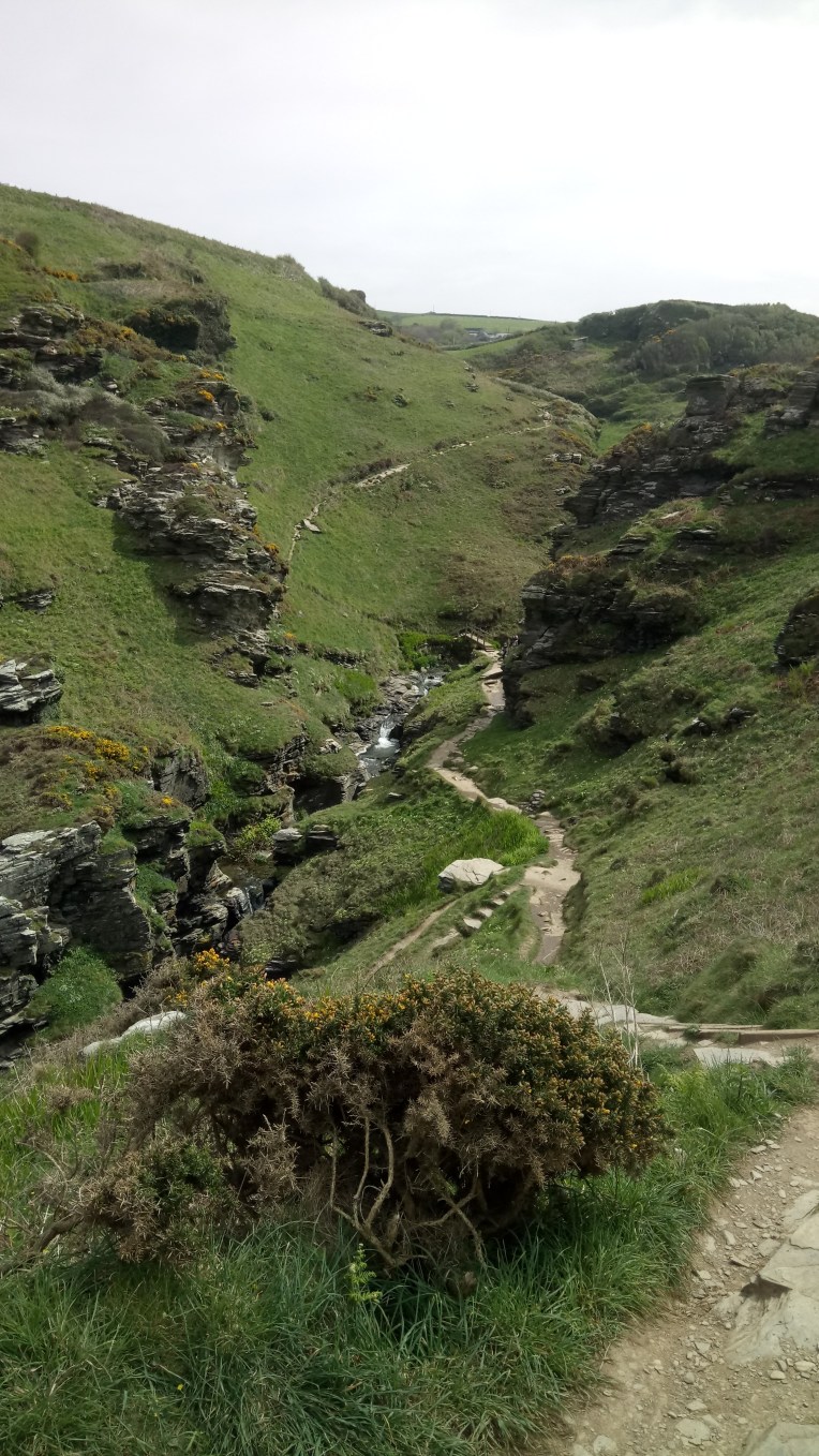
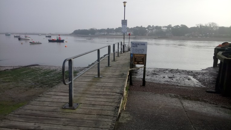
Resuming walking after leaving the car in the care of National Trust at Crantock, I took the ferry across the River Gannel to Pentire  and Towan Head and back to the ferry which had now morphed into a bridge at very low tide.

Further down stream there appears to be a stand off whilst no one does anything positive about  making safe a historic breakwater where the River enters the sea. The tides and river flow combining to alter the river bed and create potential danger to swimmers and surfers alike. Will no one do anything until there is loss of life?  It seems no one can criticise for fear of retribution. In my brief stay, I could find no one of authority from RNLI,  nor Duchy of Cornwall, nor National Trust who might tell me what the solution might be, or even if there was a problem, which the locals claim there to be. I will undertake to get some responses and hope the lack of action is because nothing needs to be done.  None of my business? Why not?

I have been asked to use my status to kick start a discussion, while all that is happening the breakwater is getting more broken.  I haven’t had a rant for a while.

Watch this space.


Back to the matter in hand – or on foot, as it were..  heading South from Crantock I clocked up various prominent heads or points and inlets, walking 14 miles to St Agnes;

West Pentire Point; Porth Joke was funny; Kelsey  Head; Holywell Bay; Penhale And Liggar Point where old Tin Mines and MoD remains remained quite untidily; not out of focus, just the sea spray.


vast Perran Beach and Penhale Sands; Perranporth and its Airport inland from Cligga Head;

and finishing the day at Peterville well short of St Agnes Head -my target, but I was too tired.


Woke up early to the dreadful news from Manchester Arena about the suicide bomber , many youngsters involved. I remember passing St Agnes Head in mist  and similarly Porthtowan , which cleared by the end of the day at Portreath following a very subdued walk. With buses back to car and camp.

I lost track of time and distance and had to be persuaded that I had one full day left before departure. Something is going on, which I find difficult to explain. I don’t know where it’s going..but read on for more serendipity or whatever   it is?


The next day’s weather was altogether different; immediate sunshine which got hotter and brighter as the day progressed. This was when I resorted to surf walking, boots slung around my shoulders and trousers rolled up; but hesitant to go topless as I already looked  the nomadic traveller and my waist to neck isn’t a pretty sight. More a bomb site. This connected I was subdued by the deaths of 22 youngsters; whereas I had always previously felt very, very lucky surviving my own personal explosion. I keep a picture just to remind me. As if that were necessary. I just don’t use mirrors. Ok. So explain the next day!

More of the same – very hot weather; tiredness; lost track of time and distance – just a target to get to St Ives. Not feeling wonderful – not ill – far too fit for that – just low. After a while I realised I kept intercepting a family group and eventually got chatting and swapped stories with St Ives getting nearer.  Sophie, Kate and Phil were from Nottingham,  whose University Nanny, Andy and Caroline know well. Phil, Sophie and Kate were constant visitors to this area and could advise me how best to quit the town. Often the start and finish of a walk gets messy with no clear directions in and out of destinations, but armed with all their accurate advice – what could go wrong. I needed a rest. I accepted their offer to buy me a coffee  –  the caffeine would keep me going; perhaps they detected something. I couldn’t help noticing Phil’s  obvious upper body scarring resulting from a childhood scalding accident, but felt entitled to ask because I had similar from an industrial accident, but self consciously kept covered.  Time has healed and we both realise actually how lucky we are. The conversation drifted to more important matters around Wembley Stadium and construction; we did not know then that Chelsea were going to lose to Arsenal  in the FA Cup Final…DSC_1517

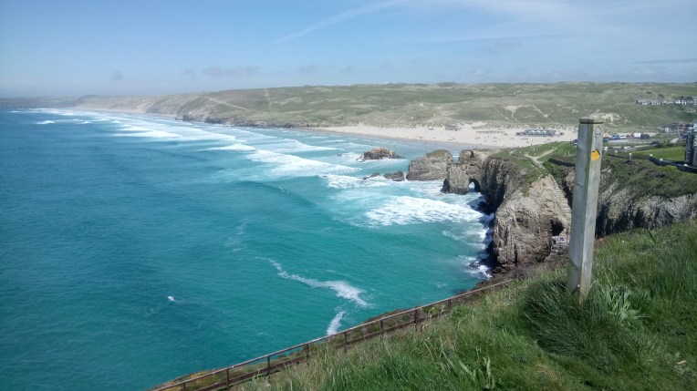
Anyway, one thing for sure I was not going anywhere further on my walk; stamina drained ; emotionally drained and full of caffeine. I was armed with directional advice. what could go wrong . Nothing. Until I found a railway station.  I saw a train about to leave, so I got on it. Well – you do don’t you. Sadly,  I couldn’t see the buffers at the front. so when it pulled out it went in the ‘wrong ‘ direction.  I asked where it was going. St Erth.  Which turned out to be only a bus ride away from Vera. Couldn’t plan it – could you?

Well serendipity – you still work. But why all the emotion?

I think the walk end is nigh and I’m going to  find something else real  to do. Like the list of 50 maintenance items at home, with supplementary list of 25 additional, less urgent matters.

On the way to Vera I found a real emporium – called The Emporium, in Hayle.

I selected two pictures, one of  Steam Locomotive  60163 ‘Tornado’ on the Dawlish sea wall. What is spooky about this? Well! Tornado was scrapped in the sixties, but a replica version has just been built by enthusiasts and is currently in fantastic demand. Also the stretch of coast track at Dawlish is famously that which was washed out just over two years ago and reinstated in record time. So I have a painting of an old express on old mainline, both of which were destroyed and have now been reincarnated.

DSC_1630.JPG

How about a Summer camped out on the Dawlish Coast awaiting the arrival of the Torbay Express hauled by 60163 Tornado? In 2017! Replicating the nineteen sixties journey in the painting. That would make a fine photo.

The other was Steam Packet Paddle Steamer advertising Atlantic Lines 1849, in wooden relief, with working clock representing the paddles.  I fear that it will go straight to the junk heap in the outbuilding. Shame – the clock still works.

Tonight Donald and I listened to a talk by Richard Parks at Hay on Wye Festival, who wrote “Beyond The Horizon”, – Extreme Adventures at the edge of the World. I told him about my Extreme walking the edge of England and he inscribed my copy “May you climb all your mountains in life… or the coastal paths!” I didn’t have the nerve to tell him about the blog.


Still0England/86 – Maisie’s Birthday Supplement and Mileage Addendum.

DSC_1405

Dear Maisie, Rowan, Jake, Stanley, Lauren and Rosie,

It was lovely to see you all in The Peak District for Maisie’s several Birthday Parties, and so much Birthday Cake!  We gathered near the banks of The River Derwent (Derbyshire Version) at Chatsworth, even though it is about as far inland as one can get, it joins the River Trent, which joins The Ouse, which joins the Humber Estuary which flows into the North Sea.  And so, we have a beautiful but somewhat tenuous  link to the Coast Walk. Although no additional miles were added to the Grand Total, it has changed significantly.

image1GOALKEEPER
Resting in Goal

Bobl needs to go back to school for Arithmetic lessons , because the Walk Auditor has spotted two errors in his adding  up. It seems around Episode 75 an extra 200 miles were credited to the account, as a result of Christmas Holidays , sick leave for a bad back and a new hard drive for the Laptop, and generally Windows 10 being a pain.  A rounding up error of one mile  was also detected by Hawkeye the Accountant in Episode 83. These excuses, plus hiding the error in between fluffy pictures should obscure the incompetence.DSC_1410

The correct Grand Total Mileage Walked is therefore 3,085 miles, in 242 days.

DSC_1413

I feel much better about this because the generally accepted England Coastline length is 2,800  miles, and allowing additional 250 miles for Offa and Hadrian, plus my predicted 275 miles to the finish, will mean only about 300 miles is unaccounted for, or as some might say, “LOST” .  I think being lost for ten per cent of the Walk is quite good?

MAISIEBIRTHDAY
Maisie, 3, surrounded by her people

Happy Birthday Maisie.  The next Birthday Party and first Teenager will be Rosie in June

.

STILL0ENGLAND/85 – 3,085 miles in 242 days Walking round England’s Coast. This three day visit to the South West Coast Path, crossing the River Yealm and filling gaps between Looe in Cornwall and Plymouth in Devon, accumulating 28 miles of which guest Elizabeth did twelve in one day.

Dear Maisie, Rowan, Jakie, Stanley, Lauren and Rosie,

Maisie’s movable  third birthday is coming up, so I’ve reversed the order of cousins to put her at the head of the table.  We will all gather together for her celebration. Although well not on the coast we shall find a Peak District river leading there and award it honorary Coastline status. But that is still to come in Episode 86.

For now  this Episode reports on the unifying  walk that turned the dislocated Crimson Worms into one continuous Crimson Worm, with its head near Padstow and the other end near Charlestown. Both in Cornwall.

Elizabeth joined us for the main walk from Looe towards Rame Head, and provided comedic relief from my solitary walking, while Marilyn acted as back up driver and mobile rest home. As with the previous guest walker, Elizabeth  also provided help with the written blogging  exercise after the walk was over. As Poette Laureatte  To The Walk she produced another poem, in honour of this part of the journey . In addition, continuous humorous conversation and evidence of also not growing up, authenticated  by various pictures to come. Again it was only when the accumulating miles approached twelve she became silent indicating lowered energy levels and well earned rest, or ice cream or forbidden alcohol….. I do believe at one rendezvous I passed silently by the back up vehicle for fear of waking her. But the rest revived her and she re-joined at the next halt.


MAPS      by courtesy of English Nature, with my completed coastal path highlighted in Crimson Worm;  singular because the North and South worms have been linked up in Episode 84. It is now a race to the bottom, at Land’s End. Unify

The Northern S W Coast Path halt is at Harlyn and Southern counterpart is at Charlestown.  Below is the overall view, still snowing in central England

map 
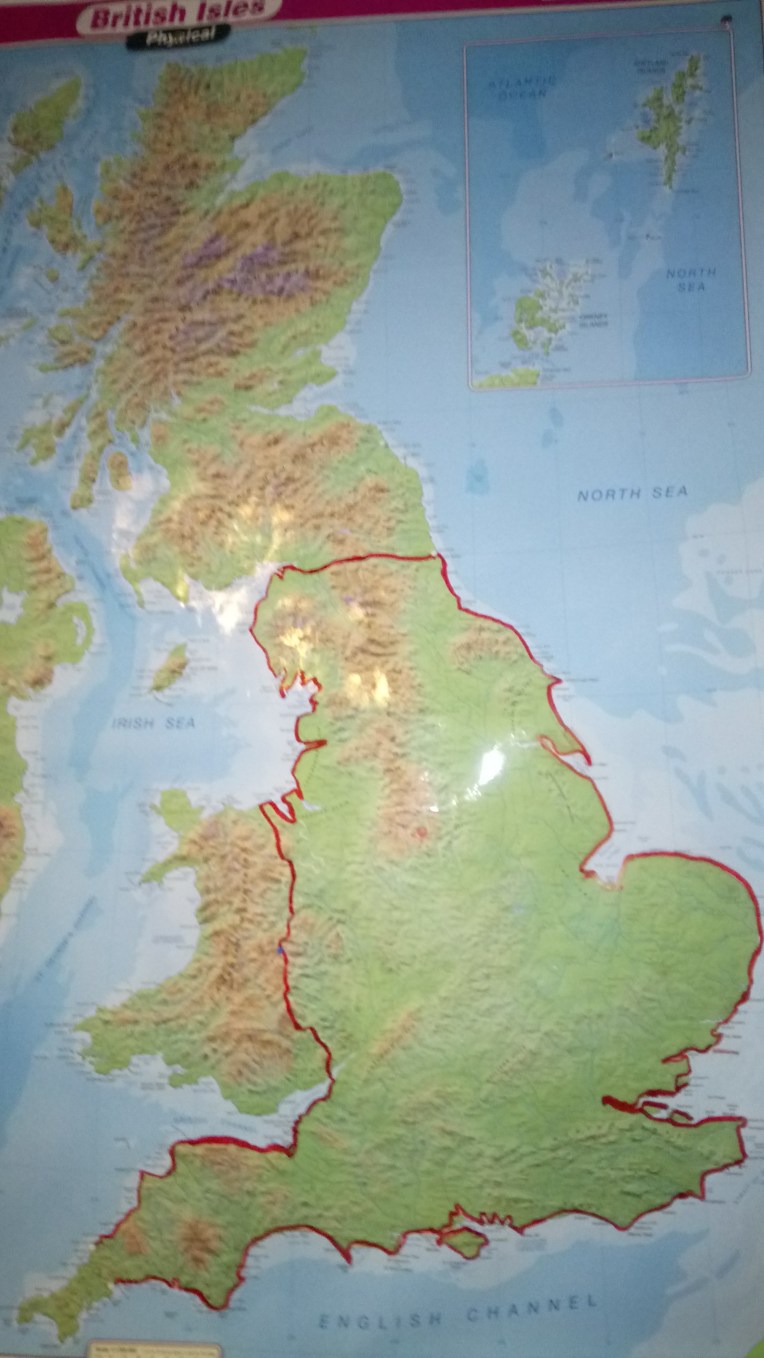
The unified Crimson Worm with both heads in Cornwall,  but a spur from Newcastle  to Berwick on Tweed remains.


This walk was 26 miles along the South West Coast Path, joining Plymouth to Looe including the Cremyll Ferry from Stone house. Elizabeth joined me on the mainland from Looe for over twelve miles heading for Rame Head.

In addition, I completed   a ferry crossing of the River Yealm  near Noss Mayo to Wembury. Last time out I got lost searching for the ferry and ran out of daylight, but this time refreshed and plenty of sunlight, I managed to complete the circuit. Billy the ferry owner took me across to Warren Point, from where the South West Coast Path resumed its way to Plymouth.


The other loose end to tidy up before our rendezvous with Elizabeth was walking through Plymouth from the Mount Batten Ferry to the Cremyll Ferry. A complete naval cityscape in total contrast to the usual clifftop walking, passing the Citadel under wraps, the Hoe, Smeaton Tower, RNLI Station at Millbay Docks, to the Cremyll Ferry at Stonehouse Marina.

Followed by the Ferry journey to Cremyll and Mount Edgcumbe and walk around Redding Point to Kingsand and Cawsand to Rame.


The next day, Elizabeth joined us after attending a family wedding in the area over the weekend. The walk  was from Looe towards Rame Head  via Seaton, Downderry, Portwrinkle   ( a prolonged stop in Honour of Marion in New Zealand), inland to avoid the Danger Area of Whitsand Bay, to Freathy and Wiggle Cliff and finally Rame Head, and rendezvous with back up at Rame Church.

And back to accommodation at Plymouth’s Premier Inn, cunningly hidden within an enormous traffic gyratory system so vast that only those born at the hotel can stay there.. We only managed by going in the “OUT” and out the “In” . Otherwise grudgingly better than sleeping in the tentDSC_1371but akin to Hotel California


Leaving Looe, The RNLI, closed so no souvenirs; The tame seal , following in Nelson’s flippers; and the pier and beach early morning.


Let’s hear from Elizabeth’s Poem interspersed with pictures….

Elizabeth joined the convoy heading East at East Looe  for Plaidey, the cliffs were unstable so the footpath changed regularly from beach to road.


“Looking for Poldark again.”

Once more along the coastal paths

And through the gorse galore,

Bob, and old school friend Elizabeth,

Walked twelve miles and more.

Ice cream, Cornish pasties,

We tasted cider too,

Up and down the cliffs and coves

On our journey out of Looe.

We loved the caves and scenery,

(Sadly, we didn’t see Poldark)

Marilyn helped with the back up car

Until it was almost dark.

Views of Plymouth entranced us both

We were grateful to arrive,

We admired the gorgeous flowers

And Elizabeth was thankful to survive.


Revived by curry late at night,

We reflected on our day,

Talland Bay provided much needed rest

And a very comfortable stay.

Bob has just two hundred miles to go,

The best is yet to come

He has worn through many boots,

And had a tonne of fun.

Bob welcomes young and old to join him!

He’s looking fit and happy,

So if you have spare holiday,

Please make it very snappy.

Elizabeth. Looe. 2017


DSC_1397

Refuelling the Back up Driver – that’s clotted cream as well….. I  think the waitress behind is bringing extra supplies?

Serendipity provided the ice cream van – we had two each – with flakes…. Paul Williams was the Ice Cream Vendor and gave us a panoramic explanation of the 360 degree view.


Next walk is the Coastline of The Peak District?  I know……


STILL0ENGLAND/84 – 3,057 Miles in 239 days. Closure on the East Coast from Felixstowe to Walton on the Naze, 26 miles.

map

Map by kind permission of Ordnance Survey, with my completed route overlay in Crimson. My very detailed coast path is shown on my highlighted collection of the individual  1:25,000 Ordnance Survey Explorer Maps. I purchased every map with blue on it. This has created confusion  – you’ll find out why in two blogs time….

Wales is next; you can see why Scotland isn’t! Nothing to do with Nicola/Alex, just the length and ruggedness of their coastline. But I do think England is entitled to a referendum to decide whether we want Scotland to be independent or not…. the result might be interesting! So says Robert Duncan McIntyre. Who, in the light of Brexit, is closely studying his NZ Naturalisation; possible Eastern European ancestry; German association by marriage; French property ownership; and Welsh connections by conductance, convection or radiation. The latter highly unlikely, as I  have no musical gene whatsoever.

More parochially, English Nature are in the process of establishing The English Coast Path, due for completion by 2020. Hopefully they will follow the same route as me. Except of course my lost bits. English  Nature estimate the total length to be about 2,800 miles, not including Offa’s Dyke Trail ,nor Hadrian’s Wall Path; thus accounting for a missing  250 miles . My current tally is over 3,000 miles and growing probably to 3,300 miles. The discrepancy is not all about getting lost – there are many circuitous walks included.

I’ve had complaints! Sorry if the map looks a bit tatty; I’ve been marking it up as I finish each incremental walk and not always in a fit and proper state; often tired and emotional. It’s on the kitchen wall! I would  ask honorary cousin Mark to turn it into a murial(sic)… but I’ve no Wembley tickets left!

So (ironic); who is going to get to Land’s End first ? Bobl North or Bobl South?

ps sorry about the snow over central England.

So! Off we go again.


Dear Rosie, Lauren, Stan, Jakie, Rowan and Maisie,

Last week, Thursday 4th May, on my 237th  Walking Day I was walking around the Essex/Suffolk border at Felixstowe, Harwich and Walton on the Naze, aiming to join together the loose ends of The Crimson Worms  and  complete a continuous path around England, from beyond Padstow in Cornwall, up  Offa’s Dyke Trail and the West Coast, across Hadrian’s Wall Path and down the East Coast, around the Thames, and coastal Kent and along the South Coast to the South West Coast Path as far as Charlestown. I’ve now set up a race to Land’s End from the North and the South S W Coast Path. I win either way.

Very first of all I had to complete a Ferry crossing of the River Deben, not operating last time I was there. At the time, I was not aware that Mr Donald Rice, our former Headmaster at Earls Hall Junior School, had recently died, and I would have called in at nearby Little Bealings to pay my respects. He was instrumental in organising the original Vectis Adventure to the Isle Of Wight, involving children from three Southend Junior Schools in 1959. Several recipients of this blog   were involved and remember him affectionately. Thank you, Mr Rice for stirring the wanderlust spirit .  Not to mention the goal nets and corner flags, that appeared shortly after his Earls Hall arrival, nor the discipline that some of us fell foul of, occasionally.

Did you see how I avoided ending that sentence with a preposition, Marie? Junior School influences endure – I know all my grammar is being scrutinised – even as I write.  R,L,S,J,R&M, one is never too old to learn. I never went on another school trip, not the fault of Vectis Adventure; just the feeling that holidays are for football and cricket etc and in between there might be room for academia. Could this be the reason why writing the blog takes up more time than walking the blog

Scarred for life…..I now am paranoid about whether ’tis Earl’s Hall; or even Earls’ Hall; or just Earls Hall? Discuss!

DSC_1263
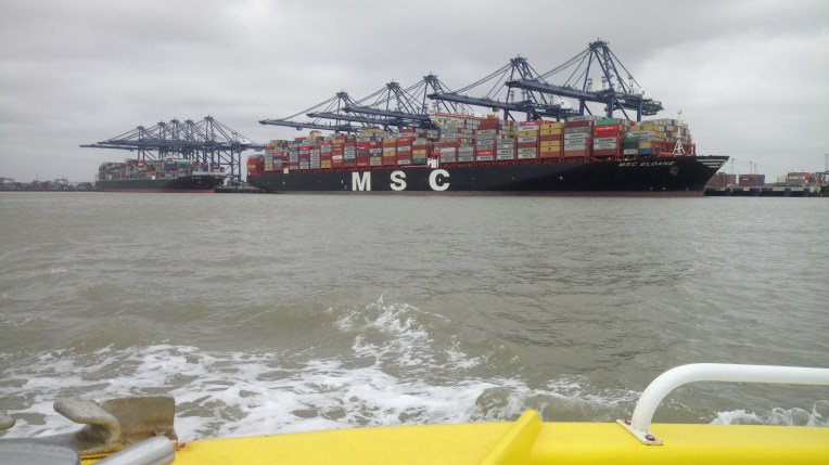
job done! Landing at Felixstowe…..

And then, similarly, I had to cross from Felixstowe, Suffolk to Harwich, Essex.

After a trip around the Harbour, I alighted at the Harwich Ferry Pier under the overseeing eye of  giant cranes on the Felixstowe side. These watched over us throughout the walk.

DSC_1261

These are they….


This 26 mile walk  from The River Deben, near Felixstowe, to Walton on the Naze completed several untidy loose ends and in the modern jargon, literally, gave me closure.  Illiterally, tiredness set in and, as a result, I got Blogger’s Block and verbal constipation, such that,  it is now several days finished yet I have written nothing.    Fortunately, my walking companion, Malcolm Mcleod, proved very much more able to provide constant good humour and written output than  walking  input, whilst operating on only one knee. Therefore you’ll be relieved to read, I have relieved myself of  writing this Episode, in favour of Malcolm, who received two written citations. One for Being the oldest guest walker, the other for completing the stretch on one knee.

I do believe that, having set the trend for guest walkers writing the blog, I predict the next Episode will follow likewise.   If only someone would take over the walking…..

In support of Malcolm’s input, I would add that, like me, he has never really grown up and he can easily attain the skills to talk up to three to nearly thirteen year old grandchildren. Let us just say the picture, taken by him, of me irrigating the countryside should have got censored.

Mrs Malcolm – or Diana – as she prefers to be known – kindly provided full board and lodging, the excellence of which was only partially subdued by Malcolm falling asleep at  the dining room table. In between mouthsful .

DSC_1299 Well, you wouldn’t look at the camera, standing alongside those pjs, would you?


Otherwise alternative accommodation was provided by  The Castle Inn Campsite at Ramsey, there’s the tent next to the toilets….


PROGRESS

map

Look! Just one Scarlet Worm stretching from past Padstow, all the way round the English Coast and back to Charlestown. The End is Nigh! Just the race to Land’s End, and The North Eastern Spur from Newcastle to Berwick on Tweed and I’m home.

Throw a double six and game over.


Rendezvous with Malcolm on Harwich Pier, with RNLI Station and shop crewed by Jim and Gerry, who sold me my Harwich Mug and a new black waterproof; how could I forget my orange outfit?


We stocked up on coffee and cakes ready for the walk in the Café on the Pier.IMG_0708[1273] cake


Let Malcolm  begin; uncensored verbatim from his email; sorry Malcolm!

“I am mobile again, but haven’t told Diana, so am getting endless streams of tea, coffee, goodies brought to me. Here are the photos and some thoughts from my side of the pain barrier which I hope will help with the blog.

So: (I do hope that’s ironic – Ed) The day was both agreeable and enjoyable despite the misconceptions that underpinned it. The first was obviously our different interpretations of the phrase “an early start”; you got up at 5-30, I arrived at 9-15.


The second was my assumption of learned and confident navigation of an O. S. Map by such an experienced traveller. However , thanks to your careful planning and my blind faith in the abilities Wally Allen had instilled in me all those years ago, we got by very well. I suppose for all who read  they may also misconstrue the word ;”ramble”; yes we walked esplanade, sea wall, seawall footpath , road, field track and back garden but “rambled” much wider in our 6 hour conversations – even if, towards the end talk was restricted to you saying “I could go and get the car; you could wait in this pub/bench/verge”.


Some highlights..

the view along the beach with serried  ranks of groynes as we left Harwich and passed the former site of “Hi Dee Hi” camp site;IMG_0713[1276]groynes


the grey menace of the North Sea (before the tide went out !);


the shifting sight of the Felixstowe Cranes which must have been on a barge so often did they appear in a different quarter of our view;IMG_0715[1265]


Confident encounters with dalmatians and hungry horses.


Your excitement at finding a sluice named after Gordon Strachan;


My excitement at finding the Maybush in Great Oakley to be open and a sandwich shop next door. I won’t mention your excitement at finding the petite Julie, a volunteer (representative hockey playing – Ed ) barmaid in this lovely community pub.IMG_0717[1267]


The road walking was harder underfoot but mitigated by the thought that we made an attractive couple so close did those blonde Essex drivers come to us. The last mile or two were  a bit of a struggle, and thanks for your patience; left to yourself, I think you would have finished, gone back and packed up your tent long before I limped home. I suppose the last memory will be that we were not arrested, for what appeared a dubious activity as you were kneeling trying to get a second knee bandage over my boot!!               (Walking the Essex Way? – Ed)

Thanks Bob – I thoroughly enjoyed the day – Malcolm


On the final day I departed from Malcolm and Diana’s home in Maldon to visit Mersea Island and take the ferry to Point Clear, thus completing  the link between North and South on the East Coast


….and home briefly before setting out for Cornwall again – Looe to Plymouth.


STILL0ENGLAND/83 – 3,029 miles in 236 days, walking the Proposed England Coast Path. 32 miles this Stretch on the South West Coast Path in north Cornwall starting at Treknow and finishing at Harlyn Beach, heading for Land’s End.

The South West Coast Path ruggedness alongside a photo of one of Nephew Mark’s ink and watercolours taken from one of my photos of Polperro…..  there’s a lot going on here. Read on.

For more of multi-talented Nephew Mark’s efforts refer—————- markbuck.myportfolio.com

That’s the same Mark who recently played Wembley…….see episode 82 ! and below.

DSC_1081

And talking of precocious talent, I learned recently, of a six year old climbing Snowdon. That’s a lot of Chocolate drops. Well done Stanley!

IMG_1606

Stan on top of Wales!

Annie, preparing for Great Birmingham10k Race with  the Birmingham University Elite… and Rosie and Lauren Elite


PROGRESS  round the S W Coast Path

Map by courtesy of English Nature. Crimson overlay by ME, showing my progress in Crimson Worms. My money is on the Northern Worm, it seems to have sneaked up on the Southern Worm but….

….the gap between  Plymouth and Looe is due to be filled next Episode. Watch this space!Mayday


A little advertising……MAYDAY!


DSC_1213

Dear Rosie, Lauren, Stan, Jake, Rowan and Maisie,

Three walking days this trip, returning to Lakefield CampSite (above) near Camelford in Cornwall, taking the tally of days walking round England’s perimeter to 236, whilst covering  3230 miles. My route is generally dictated by English Nature’s proposed England Coast Path due to be fully in place by 2020 . Navigation on the S W Coast Path is relatively easy, since there is a well worn track for well over 600 miles between Minehead and Poole. As the holiday season approaches more walkers are attacking it and it is often a case of follow-my-leader. It has to be attacked; if you don’t it’ll beat you!

Now the winter walking is almost over, I have developed a certain possessiveness and almost resent other intruders on my previously lone territory, particularly around touristy hotspots with people venturing out in inappropriate fashion; not so much baring flesh as tearing it on jagged rocks and barbed wire. Protection against the sun is difficult, with the powerful South  Western sun reflecting off the water and silica sand, and reaching all the tender places where it’s not supposed to shine!

I have a confession. I was  nearly forced to give up on this last trip. The South West Coast Path is an anachronism (look it up!). So beautiful; such colour, especially with new spring green grass shoots and bluebells, but decidedly deceptive, devious descents and ascents  and no energy left in my legs to put one foot  over the other. On the second day this trip, I had reached a point where the muscles were rebelling and nothing would work. Rests were more frequent. The stiles were higher and more cumbersome to negotiate. The sheep must be enormous here.

It was like trying to coax the last energy out of a fading battery.  No way would I ever give up, but what could I do if nothing was working? It was late, too. And I was due a rendezvous with Vera  in a Rock side street , next to a very hard place. I was losing it!

Serendipity took over. With added determination. The slope was now in my favour.  As I came down to Rock bottom at sea level to catch the ferry to Padstow, the sly, cunning contours realised they were pushing me too hard, and ahead, I detected a relaxation of the slope profile. I could look ahead at the topography and it seemed much more gentle on the other side of The River Camel, at Padstow heading for Harlyn Beach.  Perhaps I’m over the worst.  There’s something going on here that I can’t explain.  After all, I am in Arthurian Country. Very Spooky.

Unexpectedly, the ferry from Rock  to   Padstow was running a late service, and I paid the return  fare and had a relaxing, soothing, thoughtful, restful trip,  forth and back across the River Camel.  I think I caught a glimpse of a sword in the water? Excalibur….Eureka!  At the end I was almost restored and batteries recharged. And my Guini-Vera was waiting to transport me back to Camelford. Sounds a lot like Camelot….

-do you see what I did there?.

Has anyone seen my Holy Grail. It was around here somewhere?

I think I learned a lesson here – even on the walk, I should take more time out to enjoy the surroundings; whenever I walk against the clock, I lose something. So if I miss the finale in November I’ll be still out there walking some insurmountable hill, somewhere on the South West Coast Path.

Crisis over! I just lost my marbles , temporarily.

Best look at some pictures.  They are exactly as they came out of the camera – the order doesn’t stand scrutiny. I had to dodge about a bit to accommodate Vera, buses and rendezvouss. Someone tell me the plural of rendezvous. Sounds like something Rosie would know?

And something  for Rosie, Lauren, Rowan and Maisie. You must get down to see the Oss at Padstow. You will be fascinated. I got sidetracked by their preparations for Mayday and lost the S W Coast Path for a while. Perfect. More of that please! I found it again  next to a café – and a recently escaped family group of ladies celebrating their freedom –

DSC_1214

Despite appearances and my sticks rucksack and hat, I wasn’t stalking anyone…..au contraire: Three ladies escaping from eight offspring, invaded my space while I was searching for my place on the S W Coast Path out of Padstow, over a cup of coffee. I warned them standard husband procedure in these circumstances is to wind kids up, feed them raw ‘e’ numbers and sugary drinks, and let them run amok. Rosie, (not our Rosie), Anna (not our Annie) and the only Looe in Padstow will pay dearly for their escapade. Enjoy your freedom!

Lastly, commiserations for Jake; sorry about Spurs; they should have beaten Chelsea but just didn’t convert obvious superiority into goals. But they have just beaten Arsenal. Which after all is what really matters. Bit like Wednesday and United, in Sheffield, eh Rob?….but at a higher level.

Never mind, you can hope the premiership takes a dramatic twist…….  When I’ve finished walking I’ll have to get out more – and visit The New White Hart Lane. But for now , next season It’s Wembley – just like Mark.

And as I  write Auntie Annie is due to start the Great Birmingham Simplyhealth 10k Race as part of the Birmingham University Team. Picture please. It’s on Channel 5 !

Bring on the pictures – there’s a lot – I just couldn’t cull them.

Day 234 –  Thursday 27th April     Parked Vera at Treknow and back to the path exactly where I finished last time out. Over the stile, say ‘hello’ to the Path ‘did you miss me?’ and I’m back on the road again….

Leaving Vera at Treknow, soon come to Trebarwith Sand, Port William and Dennis Point. The only difficulty is dealing with a change of maps – is it 111, 109 or 106 – or all three!

Treligga Cliffs,  to Dannonchapel  and Jacket’s Point; then looking back – I’ve walked all that!

All paths lead to Port  Gaverne and Lunch at Port Isaac – and a surprise….

…..surprise is lots of people at Port Isaac. I have to find my bus stop and bus time to get back to Vera parked in Treknow for now. The surprise crowd were camp followers of Doc Martin ,now being filmed in Port Isaac. It takes over the whole village. Excellent  lunch was at Ruby Tuesday’s – after their dog – not The Stones. They  also checked out my bus timing and place of departure. All went like clockwork as you can see from my on board bus camera. Thank you. Nice salad too! They did try to ply me with ice cream, but I didn’t  succumb  –  or suck anything.  One Cornish  ice cream and I’m anybody’s.

The local bobby might arrest me….can you see who it is yet?

Mayday PC


A trip round Port Isaac  – so much going on I couldn’t resist exploring while waiting for my bus back to Treknow. The village is tightly packed and very uneven on so many levels. But  The Village seems to act together – they all support The Filming and in the black and white  days before colour was invented, they would all help when it came to launching the lifeboat through the narrow lanes – a very tight fit with men at the front steering and the rest behind pushing and shoving till they got it in the water . The safest place was up aloft on the path looking back at the harbour, although I didn’t appreciate how aloft it was going to be, later on.

Many thanks to Rock Television & Electrical Services for the parking facilities while I used up the remains of the day  bussing to Polzeath and walking back to Rock just in time to meet the evening Padstow Ferry. Why not? a return trip to Padstow beckons.

Rock  – around the Harbour to Padstow and return to Rock again. And back to the tent with twelve miles under my belt.

Day two (or 235 in total).  Walking Port Isaac to Polzeath – aiming  high  –  note all the climbs  and feeling low.

DSC_1174

Mr and Mrs Snap – kept me company  over several miles – we shared the same colour – snap! And swapped travel tales.

It’s 11-00am and I need to meet the bus at Polzeath at two minutes passed four or I’m stuck!.

I’ll take that shuttle number just in case – is it a taxi or a boat?

It’s gone midday and I’m at Port Quin – plenty of time for the bus……

twelve forty five and passing Doyden…..

…. passing Trevan Point, Pennywilgie Point and Great Lobb’s Rock nearing two pm; slight concerns for the bus….

Right now all paths lead to Polzeath and the 16-02 Bus back to Port Isaac. Approaching The Rumps and scaling mini-mountains to view The Mouls (The Island) from Rump Point used up valuable minutes  14-48pm !

Overlooking Sevensouls Rocks to The Mouls (northwards) and Sevensouls Cove (westwards) at 14-56pm. Just over an hour. I got here and I must complete the survey despite the bus…. I climbed Rumps Point – the crag in the distance beyond the worn trail guess what?  No battery charge left.  No time to fiddle with chargers. No evidence!

Now all my time left was concentrated on making the bus stop at Polzeath via Pentire Point. From my lofty position I could make out the beach and a shortcut to the bus probably a mile or so in the distance – downhill.   snaps heading for Polzeath…

and one really last shot at 15-35pm – all times taken from my camera!

DSC_1196

One really last shot of Polzeath – can you see the bus stop – centre, very back of the bay!!!…….? 15-35pm. Plenty of time? What you can’t see is Pentireglaze Haven intruding at the left front of the sandy beach. When I reached it I was crest fallen – the detour to the  left would make me miss the bus. So I carved a slippery path heading straight  for the stop….

……which I found with no idea of the time, or whether  the bus was early or late – or even running. Occupying the stop was a German Shepherd Dog and her local master, and neither knew about busses. But we all had a good doggy chat. She was a seven year English long haired German Shepherd with no sign of back trouble that afflicted Max. All timing troubles evaporated as I stroked her. Wouldn’t it be nice if I’d had Max or Jay or Sheba walking with me? But not Coco!

Guess what? The bus suddenly appeared; we barked farewell; and I was back on my walkies to Port Isaac. Sorry Flash and Cassie no doggy pictures – no battery!

So after Two days walking I had extended my Northern S W Coast Path Walk as far as Padstow, Let’s see how much further I get tomorrow. I promised myself no bus time challenges – ever again. But serendipity is still keeping an eye on me with soothing Ferry trips and playful dogs.

BYE BYE Lakefield

DSC_1197

Day three (236) saw breaking the camp at Lakefield, Lower Pendavey, Camelford, (above) and heading to Harlyn Beach South of Padstow on the River Camel. I found a public carpark that specialised in left cars while owners walked their thing on the S W Coast Path. Open, but slightly unattended. A queue formed and I began chatting to the ladies in the car behind as we wondered what to do. They were on a similar mission but heading the opposite direction to me. Curiously, our respective buses were due to leave at the same time. Here we go again – timing issues. Whilst waiting we compared notes and chatted, embarrassingly about fading memory and how I forget

a/. where I’m going

b/. where I’ve come from

c/. Where I parked Vera

4/. Where I pitched the tent

v/. Why I take photos of all the above.

.DSC_1204

Here they are; namely Cilla and Della – I think? I noted their names, but can’t remember where …. if necessary, please correct by the comment facility on the blog.  A very helpful attendant appeared and we paid up and were in business.

Aides memoires; Where I parked, how I got there and where I got to!

A trip round Padstow Harbour prior to setting off back to Harlyn Beach.

Looking back across to Rock from Padstow, where I ‘d walked yesterday. In comparison a gentle walk today, in more sandy , less rocky conditions, reaching the Lookout Station  near Stepper Point.

let’s hope these benign conditions long continue – and no more beating the clock . Just a gentle stroll back to VERA , who is being looked after in Harlyn carpark.

AS I was preparing for my departure back home  to Shropshire, a pedestrian was trying to attract my attention; memory cells whirling I realised it was Cilla or was it Della; shall we say Cedilla?  Anyway, it turns out they had waited for their bus for some time after  my bus left; they had been given the wrong time. But anyway, they had enjoyed  their walk  and returned just in time to say goodbye!

Home Vera!

Just a complimentary word about the bus services in Cornwall. I have to say they are marvellous. The drivers are helpful and how they get their machines around the tight corners and narrow roads is beyond me. What helps me most is that the various services hug the coastline and I can hop on and off, and put an end to the circuitous walks. Ruby Tuesday Café in Port Isaac donated me the current Local Bus Guide, and it is excellent with route maps and timetables – and what’s more – I’ve got my bus pass, which is kind of worn down a bit!

Thank you Busses! And Ferries! King Arthur and everyone else…

STILL0ENGLAND/82 – 3,000 miles and 233 days walking THE PROPOSED ENGLAND COAST PATH. This stretch in North Cornwall on the S W Coast Path covers 31 miles from Foxhole Point Lookout over Widemouth Bay to Tregatta, South of Tintagel. Added Bonus – Mark plays Wembley……

My guide, in 82 Episodes so far, to our six Grandchidren about how to walk around England’s coast before the formal England Coast Path is completed in 2020 by Natural England. If you find it difficult reading content aimed at intellects of toddlers to nearly teenagers, apply below for the dumbed-down adult version.

My Walk started around November 2013, and will finish on Southend Pier four years later 11th November 2017.Celebrating with  Bread pudding and bubbles. See you there?  1-00pm prompt.  Deep end.


The map below, shows the race to the bottom of the Cornish Peninsular at Land’s End. When the Crimson Worms link up, I’ll be nearly finished walking round EnglandEpisode 82

Map by Courtesy of Natural England – my ramblings added in Crimson. If you trace the Crimson Worms back, they almost link up at Harwich, with a missing Northern branch from Newcastle to Berwick on Tweed. The next two outings should eliminate the gap between Plymouth and Looe on the Southern S W  Coast Path and extend the Northern S W Coast Path beyond Newquay.  Keep up!

Are you sitting comfortably?

Then I’ll begin.


Dear Rosie, Lauren, Stan, Jake, Rowan and Maisie

I am often asked how many pairs of boots I’ve worn out so far whilst completing nearly 3,200 miles walking round England. The truth is, I’ve lost count , but here is a view of the current foot  squad, not including the latest transfer I was acclimatizing  on the  Wembley terraces, last Saturday and Sunday at the F A Cup Semi-Finals.

These boots were made for walking, alongside Widemouth Bay where they finished last time out, worn out, resulting in new footwear investment  – to see me through to the end? What I really need is new legs and a bit more ooomphff!

The omens are not good; Spurs lost the Semi-Final and dropped out of the F A Cup; only an almost impossible  effort in the Premiership will give them a trophy this year. My walk is beginning to feel the same way. The spectacular views of The S W Coast Path are matched only by the Herculean effort need to complete the final few hundred  miles of roller coaster terrain. I’m still struggling, and not encouraged by reading that the whole 620 miles of the S W Coast Path contain the equivalent of  ascending and descending Mount Everest three times…..  let us say I’m at the low point right now. But no surrender – next time out I’m going to give the S W Coast Path a good kicking from here to Padstow and hopefully beyond.

But the gloom was entirely dispersed by your several times very removed cousin Mark who discovered an unattended grand piano in the Wembley Stadium foyer and treated  very surprised football fans to a spontaneous concert and all that sort of jazz. With an encore!

DSC_1081

Mark playing Wembley     —The highlight of my weekend – until…..

I heard Stanley and Rowan were discovering that long suffering, longstanding but very much younger than Mark, partner, Borough Commander Justina was actually in charge of painting real fire engines red.  I expect  they can’t wait to see her in full uniform. I think that probably goes for most of us too.  I feel better already. In recognition B C Justina is now Honorary Walk Fire Warden and Mark is ordained as Cultural Attachee with Special Responsibility for All Grand Pianos encountered from now to the end of The Walk.

Walk on

Walk  on

With hope in your hearts……                               ‘cos that’s about all that’s left in the tank.

All help gratefully received.


This last trip covered from South of Widemouth Bay to Tregatta just South of Tintagel. There was a bit of circuitous walking to get going but most of the 31 miles walked  over three days counted directly towards reducing the outstanding tally to complete the whole trip, and for once I didn’t get lost.

In Cornwall, I stayed in another Equestrian Campsite, Lakefield, near Lower Pendavey, not far from Camelford on the A39. The scene of my culinary discovery that A Proper Cornish Pasty fits neatly in my  electricsandwichmaker  in preparation for its journey to my stomach – and beyond. I have two serving options – burnt, or very burnt. Tasty.

Lakefield Camp Site, Lower Pendavey Farm and Equestrian Centre with some four legged campers wrapped up warm at sunrise.


The weather became unseasonably warm, with enough sun to remind me to take the sun screen lotion next time. I can probably start reducing my back pack and discard the wet weather gear and full change of clothing, making room for more water, wet and dried fruit, nuts and medicinal chocolate. The twin turbo walking sticks are now a permanent feature, I am beginning to rely rather too heavily on them.


And now the journey in pictures – just let me qualify the  quality by saying none of them do justice to the magnificent scenery I am fighting my way through.


The first day, Tuesday 18th April, 2017, Walking Day 231, resuming from Foxhole Point, Widemouth Bay, a circular walk via Millook, Lower Tresmorne and Dizzard Point finishing at sunset by Moshole Cave.


The second day started by parking in Boscastle  with a 96  bus trip to Crackington Haven and a short circuit walk to last night’s rendezvous just beyond Cleave and back to the Haven. A selection of buses and bus stops below


And a selection from the circuit round St Genny’s, the climbs were  foretelling what was to come.


Before going down towards  the Haven I met Jo and Andy heading the opposite way. They were from Shoreham and Burton respectively and enjoying walking in  the midday sun. They were very interested in My  Walk and respective photos were exchanged. I hope I’ve helped sow the seeds of another long distance walking project. I think they’ve got a bit more time on their side.

DSC_1011


And here starts the strenuous journey between Crackington Haven and Boscastle, re-living the climbs up and down hurts.


There are 620 miles of South West Coast Path. I’m glad to say I have nearly finished because most of it is energy sapping, but nothing I can write can describe the beauty of it all. I will miss that , but not the constant need to attack another slope.


On the last walk of the second  walking day, 232, it seemed to take forever. I was returning to Boscastle, but I  found The Cobweb for a restorative drink before camping for the night.


I’m afraid the final day walking was not fully recorded in pictures, not only had I run out of steam, but also the camera and back up batteries were drained, so forgive the slight scramble to the finishing line.

Dropped in the middle of nowhere, or Tregatta, by the very helpful bus and driver, I was soon back on the S W Coast Path heading back to Boscastle. Meanwhile I rediscovered Youth Hostels, very unlike those of fifty years hence, when I qualified. Wifi and electrics. All very modern and accommodating. And no chores! And the familiar National Trust signs are in abundance.


 In and around Tintagel, getting a bit built up  on MY Walk, and positively crowded and stuffed up with  queues to get on the island, but after blowing Barras Nose it calmed down a bit.


DSC_1072

Rocky Valley – quite breath taking in every sense


DSC_1073

Approaching Boscastle…..


…..And finally one for Mark in Boscastle Harbour


DSC_1076


Below…..and this is what he does with my photos……..

DSC_1084.JPG


Still0England/81 – 2,969 miles and 230 days walking the English Coastline. This visit to the S W Coast Path from South Hole Farm in Devon, crossing the Cornish Border heading South and finishing at Foxhole Point Lookout after 18 miles.


Bude.jpg
The Northern Crimson Worm has reached South of Bude; whereas its Southern counterpart has got dislocated at Plymouth and Looe. It won’t be reconnected until May, this year.                         Map by courtesy of Natural England with added crimson blood by Bobl


DSC_0935

Okehampton  Camp site for one night only, Travelodge at rear – because I was accompanied by back up crew of Nanny  driving Vera,  my normal sub-standards were not acceptable; so no sleeping under canvas; no eating out of chilly bins or Thermos flasks, nor camp fires. Instead we patronised  the delights above and adjourn to an attached heated hotel, with real beds, pillows, duvets, Wi-Fi, tv, showers, bath and electricity. I think the only mod-con I’d swap would be the bath! The rest will turn me into a softee. But it’s worth it to have Nanny  alongside…. with Vera! Even though you’d refuse me admittance if you’d have seen the state of me after a day’s session on the washed out S W Coast Path  – but I did remove my boots. Phew!


DSC_0050[830]
Starting out on the first day under a heavy sky  and surface water following  last nights storm


Dear Rosie, Lauren, Stan, Jake, Rowan and Maisie,

The Walk has decidedly gone beyond the point of no return, but is it about to reach the point of no completion? I have inadvertently managed to leave the most strenuous and inaccessible parts  until the end. With the self imposed November deadline getting nearer the finishing line seems to be getting further away. I thought my energy levels of last year would return after hibernation, but I’m struggling, and this accompanied trip was intended to remove any anxieties about running out of time. But instead running out of energy is a worry. My advice to you is start your walk round England with the South West Coast Path, and if possible, the downhill bits only.

The point I’ve reached on the northern section of the  South West Coast Path approaching Bude has to be the most scenic and the most undulating, and following a night’s incessant rain, the most flooded and muddiest and relatively remote. I needed the back up crew  alongside because I was well out of reach of public transport and emergency services and circuitous walking doubles the time taken to make forward progress on the overall walk. All my miles counted this trip, even though my targets were severely curtailed by muddy climbs, descents and a  wind that blew Nanny back to the car, abandoning any walking  company but no ‘lost’ miles. Although I lost count of the number of times I ascended and descended between sea level and one hundred and fifty metres. I found each climb enery sapping and debilitating.  I tried beach walking, but only once. I traversed a flooded brook at the inappropriately named  Welcombe Mouth  by wading across hoping that there was a way out at the other end of the beach. Progress over the wet, slippery boulders and newly fallen cliff faces was even slower than keeping to the undulating Coast Path.

I could only take two days of this relentless slog. The views were fabulous and the worst of the weather occurred whilst I was not walking – except the wind. On the first day it was right behind me, but by day two it had turned into my face and I called it a day at Foxhole Point, a beautiful vista looking back at most of the eighteen miles I had just walked. Far from being downhearted at the reduced mileage, I was elated by looking back at where I’ been walking and comforted by knowing I’d overcome some of the trickier climbs on the whole S W Coast Path.  And I didn’t have to drive home. So I slept! And finishing doubts evaporated.


PROGRESS IN PICTURES

Starting out from South Hole Farm, passing Embury Beacon  157m, Welcome Mouth, Marsland Cliff,  Henna Cliff 143m  to Vicarage Cliff and Morwenstow.


More National Trust Territory at Vicarage Cliff and Tidna Chute  and progress toward Steeple Point whilst trying not to capture the very prominent Radio Station in my lens.


The tail of Brer Robert –

Are you sitting comfortably?

Then I’ll begin.


It’s very hard to ignore the Radio Station perched upon Harscott Cliff at Spot level 129 metres. There are many huge satellite dishes laid out behind security fences and for reasons of National Security, I did not want any evidence on my camera. It would be difficult in any remote area to persuade  determined  spycatchers that I am walking England’s perimeter for fun and not for clandestine nefarious purposes.

As I nonchalantly strolled by, I missed a very sharp Right hand turn towards Reed Rocks and gradually immersed myself in brambles and overgrowth, and determined not to miss a short cut decided it was prudent to force my way through. After a while the thorns had actually extracted my bootlaces and I was in danger of losing my boots. I backtracked and after an hour stuck in this briar patch with the sun descending and late for my Duckpool Cottage back-up  rendezvous, managed to return to where I had started..

It amazes me that for the period of incarceration no bells, whistles, alarms, bullets or rockets came my way. Not even a “What the hell do you think you’re doing?”.

Maybe a couple of squaddies were ‘aving a larf following my every false move on CCTV. Half expected to go viral on you tube!


Approaching the end of the first day’s walk at Steeple Point and  Duckpool Cottage and a timely appearance of the sun  – and my lift back to  civilisation – or not? Minus bootlaces.                               N.B. Brambles!


DSC_0936

The next day,  on my way again but looking back at Steeple Point and The Duck Pool, with the SW Coast Path quite clearly descending rapidly to sea level from 129 metres at the Radio Station…..


Heading for Warren Point after leaving from Duckpool Cottages and over the footbridge


Sandymouth Beach in Bude Bay


DSC_0942

The National Trust were asking for donations;  being a paid up member I found no problem leaving an extra deposit… an ingenious selfie arrangement that took ages – but I needed a rest!


DSC_0943

Surf’s up!  Except it’s 150 metres below


Outgoing tide at Bude where the canal and River Neet or Strat join the sea;  and Rosie’s Café at Crooklets Beach


DSC_0059_1[836]

Widemouth Bay from Lower Longbeak – shortly after Nanny joined the walk – until the wind blew  her back to Vera.


DSC_0965

Widemouth Bay from Foxhole Point lookout.  A final view before the final rendezvous and drive back home and sleep…zzzzzz!  Shhhhh!


StillOEngland/80 – 2,951 miles in 228 days walking around England’s Coastline. This visit on the Suffolk Coast Path, 20 miles from Shingle Street to Landguard Point, and 12 miles from Clacton to Walton on The Naze on the Essex Coast.

Slight cause for concern…….. you may not be too surprised to learn that, for the second time I have filled up a whole blogsworth of cyber space. Therefore, at vast expense, I have upgraded to  WordPress ‘Personal’ status, which allegedly allows me to continue blogging with my own domain name amongst other things. I don’t profess to fully comprehend what I have now unleashed, but the immediate effect was like writer’s block release, and there should be more than enough capacity to complete my record of  the walk round England, and maybe Wales too? The concern is that I’m not too sure what the blog is called any more…. but rest assured that when I find out you’ll be one of the first to know……previously I was ‘still0england.wordpress.com’                                                           Now I think I’m ‘still0england.com’  but I’m still waiting for confirmation!

ps Anyone out there who can work out what I’ve done please advise asap…


Dear Rosie, Lauren, Stan, Jake, Rowan and Maisie,


Working together…..

Well done Rosie and Lauren for your dancing performances; Encore! Nanny says you were both the stars of the show as always, a very great effort.

Stan for helping Rowan through their first scheduled joint Rugby training;

And Jake and Maisie for getting through the final stages of Chicken Pox – always a scratchy time. They can’t wait to get back to tennis and ballet..

This most recent walk was intended to finish off the East Coast but instead  was a forgettable, complicated and altogether confusing trip that probably protracted my adventure rather than bring the finishing line closer. ‘ Forgettable’ in the way that I am having difficulty in retrospect,  piecing together the evidence of how, when and where I walked  and twice I forgot where the car was..We won’t go into the whyfores….  ‘Complicated’ in the logistics required to accomplish all the salient landmarks along the route. Felixstow is a mile or so  across the Stour and  Orwell  Harbour  from Harwich but forty miles by road and the passenger ferry is out of season. ‘Confusing’, because .. well I am easily rattled, particularly after the second time I couldn’t find Vera. I won’t say I lost it but it did take a while to rendezvous.  Fortunately the car turned up – once by Clacton Pier and again at Walton Pier. Exactly where I’d left my motorhome from home.

Serendipity returned and conjured up buses when I needed them most. Even when I got on the wrong route the bus crew kindly stopped and put me on the right route, which happened to be the bus behind. Yes …. I do use the seats reserved for elderly passengers. And the sticks, rucksack and walking gear mean the drivers wait for me to be seated. No! I am not getting past it!

The intention this visit was to complete The Walk on the East Coast by joining Clacton in Essex to Shingle Street in Suffolk, but I underestimated the logistics required to overcome the Rivers Deben, Orwell and Stour, and  inaccessible peninsulars of Felixstow, Harwich and Walton on the Naze, and so I have to return to complete a couple of ferry trips and join Harwich to Walton via Great and Little Oakley and Thorpe and Kirby le Soken, as I circumnavigate Pennyhole Bay.

In map form, courtesy of Ordnance Survey, and apologies for the heavy snowfall over Jake and Maisie in the Peak District; –

DSC_1042

There is about a twelve mile gap before the  Crimson Worms  join up on the East Coast, North Essex.  Which means only 274 miles of  the Cornish peninsular and about 75 miles between  Tynemouth to Berwick to complete by November. Nearly there?  Hopefully under 400 miles but you can never tell with the circuitous routes taken in the more remote and isolated parts.

The Walk

I returned  to the Valley Farm Horse Riding and Driving Campsite near Wickham Market in Suffolk, and after an unsteady night, was able to see the early morning horse mustering while I ate my breakfast. I had been unable to sleep on this clear moonlit  night because, from  within the frail protection of my tent, I could hear the horses chomping away, without being altogether sure if they were horses, or loose cows or even a bull!  I knew the camel , alpacas and other farmyard animals were  elsewhere. Several times in the night I got up to check who was where and that my sticks were handy.

There was one naughty pony on the breakfast round up, who delighted in taking some of his mates way off in the paddocks, where the grooms  had to walk far out of their way to gather them in. Eventually they responded to the sound of food bowls being bashed. And I made my escape to resume the walk  from Shingle Street to Bawdsey. Perhaps ‘next time’ I might do the trip on horseback………………………..DSC_1015

Entrance to the riding school and campsite….

DSC_1013

These horses wanted  their breakfast more than the naughty pony who led a mutiny to the furthest paddock!

The Coastguard Cottages at Shingle Street where my  coastal walk from Suffolk to Essex resumed

DSC_0976.JPG

DSC_0973DSC_0975

Typical Shingle Suffolk Coast, seawalls and Martello Towers

Sea defences get dilapidated over the years but still just manage to keep the sea out.

The tide going out at the River Deben. Time to return to the tent and horses, where I found a package of Horse Brochures from the Campsite owners addressed to Rosie, Lauren, Stan, Jake, Rowan and Maisie. Thank you!

Sunrise, the next morning, at Felixstow.

DSC_0979

…..and below, the business end of Felixstow,  the deep water harbour with millions of containers being exchanged.

DSC_0990

DSC_0986

and at the other end of the scale – Old Felixstow – Deben Ferry but not till Summer.

Landguard Fort, Jetty, Point and Nature Reserve formerly a  prominent military defence base and home to Flying boat development now given over to more peaceful conservational activities.

Felixstowe Pier and promenade – not open for business yet

And now North Essex, extending The Walk from Clacton to Walton on The Naze   but there’s a big photographic gap. Not only do I lose Vera but I left the phone/camera/lifeline with her as well – so no pictures until we’re reunited  – hence the montage of Walton Pier and views below. Sorry Frinton but you got missed out, although I did walk your pleasant beach and I suspect you are somewhere in the distance in the shots taken from the pier head.

Below, Walton Lifeboats and Stations, old and new, on the pier and on the shore…. 

Walton Beach, approaching The Naze

DSC_1032

Finally, not completing the allotted schedule; still a twelve mile gap between here below at Walton on the Naze and Harwich, a passenger ferry ride away from Felixstowe, across where the Rivers Stour and Orwell meet.  

That’s it – a bit disjointed but so was I! My starting point next time out will be Walton Pier heading for Kirby/Thorpe le Sokens and the  Oakleys and finally Harwich to join up the Crimson Worm by taking the ferry to Felixstow.

Update- last Episode I indicated that I would consult English Nature about the correct route of the England Coast Path around Orford Ness. I did have a very informative discussion with Charlotte, who was overseeing the path as far as Aldeburgh. Unfortunately, the personnel for  next Stretch- Orford heading South have  not been decided yet and so no plans have yet been undertaken. Charlotte took note of all my comments and asked for contact details should anyone wish to further discuss. It was interesting to learn that the criteria, and particularly the legislation, adopted to put the County Coast Paths in place  differs significantly from that for the proposed  England Coast Path.

StillOEngland/79 -225Days walking 2,919 miles around England’s Coastline. 41 miles this trip on the Suffolk Coast Path from Sizewell Nuclear Power Station to Coastguard Cottages at Hollesley Bay.

Diversions.

The Map below, courtesy of Natural England shows the intended route for the England Coast Path. Unfortunately, access to Orford Ness is restricted and the alternative route followed by Suffolk Coast Path goes inland via The Snape Maltings, my preferred option.

Similarly, the Proposed England Coast Path route  follows the Rivers Deben, Orwell and Stour inland, whereas the Suffolk Coast Path prefers the ferries that link up with The Essex Way from Felixstow to Harwich. I will discuss the position with English Nature!

aldeburgh

No crimson worms – all colours represent Natural England’s proposals to open The England Coast Path by 2020. In hindsight they might care to reflect on whether the final route follows the coast around Orford Ness, or the less daunting Suffolk Coast Path via The Snape Maltings.

PRE-RAMBLE.

And rant – haven’t had one for a while.

If you have stumbled across this blog unintentionally, the previous 78 Episodes have described almost each pace of my journey around England’s Coastline, in the form of a letter to our Grandchildren. If you can’t handle the level of intellect required to communicate with two to twelve year olds then abort now, or just look at the pictures, otherwise you will be asleep in minutes.

This particular episode describes my journey on the Suffolk Coast Path from Sizewell, through Thorpeness, to Aldeburgh; inland along the Sailors  Path to The Snape Maltings; returning to the coast via Chillesford, Orford and Boyton; eventually finishing near Shingle Street where the River Ore breaks out into Hollesley Bay.

Because of the remoteness and lack of public transport, much of he walking was duplicated by circuitous routes, but all the time attempting to keep to the proposed English Coast Path. I will be seriously interested on which route they eventually decide  around Orford Ness. Suffice to say my route started at Sizewell and ended at Coastguard Cottages, near Shingle Street.

Walking the coastline is the easy bit. Just one foot in front of the 0ther. Admittedly going off level gets harder. Personally, I need the grandkids  input to handle the myriad  difficulties I experience just trying to write the record. I am convinced that Gremlins are employed specifically to confuse me, the moment I appear to comprehend the workings of the blog. It’s never the same twice. It’s not improvement or fine tuning – it’s harassment.

And who begat Windows ten? Who  is responsible for the moving target that is my screen?  I can’t begin to describe the contortions needed to pin it down while I attempt to  inflict some writing. There was little wrong with Windows Seven and the font did not reduce/grow/disappear/correct/admonish and generally slither around while I didn’t even go near the keyboard. All very disconcerting and spooky. My fault for dropping the laptop and rearranging the hard drive. Unfortunately the new hard drive censored most of my address book, which is probably a great relief to those not now receiving my missives.

I’m amazed I got away with writing all the above unmolested, although I think I’ve developed a nervous tick. But I am hugely impressed with the pictures. The technology that produces such quality never fails to amaze me, but the Grandkids will take it all in their stride, whilst I resort to quill and inkpot to scribe,  and surrogate Grandchild Mark, watercolours to illustrate. His work is incredible and you would agree, if only  I could find out how the hell I can transfer some of his watercolours to my screen without getting paint over everything. Why not look at his website .  https://markbuck.myportfolio.com

Now for the real blog – rant over….

Hi Rosie, Lauren, Stan, Jake, Rowan and Maisie,

We negotiated  two birthdays in seven days, Stan and Jakie,  six and five, and presents of Crawler Caterpillar Tractor and Tennis Racket  respectively. Both long standing requests and well earned. Look at the pictures carefully and you’ll see I captured a real life tractor just like your scale model, Stan. And as for Jake’s tennis prowess, the moment he starts emulating Andy Murray, I’ll whisk him off to David Lloyd. We need no introduction , do we Henry? Those were the days…..

Looking at the spread sheet we can have a breather before the next celebration, Rowan is four in April. Although not forgetting Nanny  next week! She will be twenty one again.

Well done Rosie and Lauren – you both have extra special mention in despatches and Maisie was very grown up in her big girls outfit for Jake’s party. Boys were outnumbered nine to five. I foresee interesting times in parties yet to come!

Valley Farm Camp Site – lonely – apart from the horses – and the camel! I was surprised – the fence was alarmed

The remains of the day  of my arrival I managed a circular walk of about 9 miles  between Sizewell, Thorpeness and Aldeburgh. Mostly along the beach but on the return journey I ventured inland for variation.

The Beach at Sizewell with the Nuclear Power Station looming over the fishing boats

The Suffolk Coast Path is a bit of a misnomer; I  rejoined it at Sizewell in full view of the Nuclear Power Station and kept to the beach through Thorpeness and beyond to Aldeburgh, but after that it turns inland……

The shallow cliffs from Sizewell to Aldeburgh are quite feeble and prone to erosion, but some householders always look on the bright side despite the encroaching sea….

The Coast Path skirts Aldeburgh but I took time out to pay a visit and view the artistic community 

The Sailors’ Path offered Snape Residents easy access to Aldeburgh, a thriving centre for fishing, boat-building  and smuggling – not now – of course….

But after that the Suffolk Coast Path, here, renamed The Sailor’s Path, headed inland towards The Snape to skirt the complications caused by the River Alde and the River Ore meeting each other and the forbidden Orford Ness. All sorts of wartime experiments and cold war activities, have gone on at Orford Ness but it is now the responsibility of the National Trust and is partly a National Nature Reserve. The Ordnance Survey Map indicates a radio station with many masts. All of which makes it hard to visit, particularly since the Ferry doesn’t operate until Easter. Even then access is very limited.

I took time to visit Orford but since it is not on the designated Coast path I didn’t waste too much energy  other than contemplating the setting sun. The hidden depths of the place are referred to in Patrick Barkham’s book Coastlines; nothing was written that made me want to visit! Eerie!

Just for the record – two views of Orford, just in case they re-route the English coast path via Orford Ness, but I didn’t like the feel of the place..

I paid my respects to the Snape Maltings, where earlier on I had left ashes belonging to Yvonne Pedretti, who  had worked and  exhibited  there. She had charged me with the responsibility of  depositing her ashes at several places, some in Southend,  others further afield, but I’m happy to say I was able to   reasonably comply with her wishes, each  time reciting G K Chesterton’s  “Rolling English Road”. The verses of which seemed highly appropriate to my English Coast Walk, which is why I  adopted it as my anthem.

Snape Maltings and Bridge over the River Alde  – artistic community – and bus stop for the return to Aldeburgh.

The Path then heads back towards the Coast via Tunstall Forest, Chillesford, Butley Abbey and meets the River Ore at Boyton Marshes. This runs parallel with the coast but does not enter the sea until a few miles later where it merges at North Weir Point,  Hollesley Bay

The one aspect that was quite a relief after the undulations of the South West Coast Path was the relatively  level walking and good paths, if you ignore the general mud surrounding the pigs  . I didn’t even unwrap my sticks. But the only inconvenience of this particular three day  walk was lack of public transport. Only the 65 Bus from Aldeburgh to Snape provided any relief from circuitous walking. All other routes I tried to vary the circular route so that I retraced my steps as little as possible.

Random Pictures – out of sequence but too good to be ignored……..

This is Pig Country – all that separated me from massive sows and numerous piglets was a single strand electric fence just off the ground – if the grumpy sow thought I was after her brood no fence would have stopped her. You’d be grumpy with all those piglets; they didn’t bother with the fence and just ran amok.

Butley Ferry and operating instructions on the  Butley River… not much use  till Easter

dsc_0961

One of the locals at Capel St Andrew..

Black heath Wood on The Sailor’s Path

dsc_0944

Stanley’s Birthday Present – a creepy, crawly, smelly, muddy and noisy tractor – the farmers didn’t lack modern machinery.

dsc_0946 Pig Food above and  Butley Mill holiday venue below…

dsc_0948

And finally the approach to Coastguard Cottages and Shingle Beach, where this walk ended.